IMAGES TAKEN NEAR TO
Jack Straws Lane, OXFORD, OX3 0DL
Introduction
This page details the photographs taken nearby to Jack Straws Lane, OX3 0DL by members of the Geograph project.
The Geograph project started in 2005 with the aim of publishing, organising and preserving representative images for every square kilometre of Great Britain, Ireland and the Isle of Man.

There are currently over 7.5m images from over14,400 individuals and you can help contribute to the project by visiting https://www.geograph.org.uk
Image Map
Images are licensed for reuse under creativecommons.org/licenses/by-sa/2.0
Notes
- Clicking on the map will re-center to the selected point.
- The higher the marker number, the further away the image location is from the centre of the postcode.
Image Listing (24 Images Found)
Images are licensed for reuse under creativecommons.org/licenses/by-sa/2.0
Image
Details
Distance
1
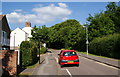
Jack Straws Lane, New Marston
There is a wooded section midaway along this road, but the area is only front gardens of larger houses.
Image: © Bill Boaden
Taken: 25 Jun 2010
0.03 miles
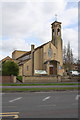
2
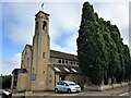
St Michael and All Angels, New Marston
New Marston is well served by this handsome church with its campanile and unusual oval windows, dating from 1955. This view is of the approach from Jack Straw's Lane along the south side of the church. Visiting as part of the 2019 Ride and Stride charity event, I was welcomed by a member of the congregation. The interior is adorned with carved pillars depicting Bible stories, each of which includes an angel. https://www.stmichaelandallangelsnewmarston.org.uk/
Image: © HelenK
Taken: 14 Sep 2019
0.11 miles
3
St Michael & All Angels
Visited on the off chance it would be open, sadly not. The church was built in 1954 along the Marston Road.
Image: © Bill Nicholls
Taken: 14 Sep 2022
0.11 miles
4
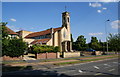
St Michael & All Angels, New Marston
This is not obvious C of E architecture.
Image: © Bill Boaden
Taken: 25 Jun 2010
0.11 miles
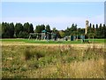
5
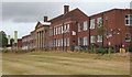
Headington Hill, Oxford
This, the front elevation of the Oxford Brookes University Marston Road Campus, looks out over an extensive public recreation ground called Milham Ford Nature Park, albeit that this is simply a 16 acre (6.5 ha) grassed area incorporating a children's playground area. The building functioned as Milham Ford School during 1938-2003. It became a girls' grammar school in 1944 and a girls' comprehensive school in 1974. However, the University's School of Health and Social Care has occupied the building since 2004. The main entrances are via Jack Straw's Lane and McCabe Place, each of which approach one of the building's end elevations.
Image: © David Hallam-Jones
Taken: 1 Aug 2013
0.11 miles
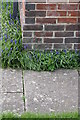
6
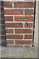
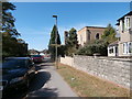
Benchmark on end of party wall of #294 Marston Road
Ordnance Survey cut mark benchmark described on the Bench Mark Database at http://www.bench-marks.org.uk/bm56310
Image: © Roger Templeman
Taken: 24 Mar 2014
0.12 miles
7
St Michael and All Saints' Church, Marston Road
There is an OS benchmark Image on the brick wall pier near the left hand side of the image
Image: © Roger Templeman
Taken: 24 Mar 2014
0.12 miles
9
Benchmark on #2 Croft Road
Ordnance Survey benchmark described on the Bench Mark Database at http://www.bench-marks.org.uk/bm56312
Image: © Roger Templeman
Taken: 24 Mar 2014
0.14 miles
10
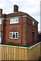
#2 Croft Road
There is an OS benchmark Image on the side of the house at the near corner
Image: © Roger Templeman
Taken: 24 Mar 2014
0.15 miles