IMAGES TAKEN NEAR TO
Copse Lane, OXFORD, OX3 0AY
Introduction
This page details the photographs taken nearby to Copse Lane, OX3 0AY by members of the Geograph project.
The Geograph project started in 2005 with the aim of publishing, organising and preserving representative images for every square kilometre of Great Britain, Ireland and the Isle of Man.

There are currently over 7.5m images from over14,400 individuals and you can help contribute to the project by visiting https://www.geograph.org.uk
Image Map
Images are licensed for reuse under creativecommons.org/licenses/by-sa/2.0
Notes
- Clicking on the map will re-center to the selected point.
- The higher the marker number, the further away the image location is from the centre of the postcode.
Image Listing (48 Images Found)
Images are licensed for reuse under creativecommons.org/licenses/by-sa/2.0
Image
Details
Distance
1
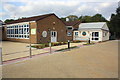
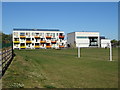
Buildings at New Marston County Primary School
Image: © Roger Templeman
Taken: 9 Sep 2015
0.02 miles
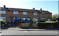
2
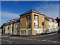
Flats on the corner of Copse Lane and Eden Drive
The flats were built on the site of the former Cavalier pub.
Image: © Steve Daniels
Taken: 16 Jul 2016
0.03 miles
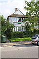
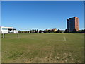
8
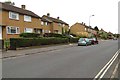
Copse Lane in Marston
The junction of Copse Lane, Westlands Drive and Ambleside Drive.
Image: © Steve Daniels
Taken: 13 Aug 2013
0.10 miles
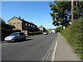
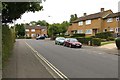
10

Oxford Panoramic
View of the surrounding area by the Jr hospital in panoramic form
Image: © Bill Nicholls
Taken: 7 Jun 2014
0.13 miles