IMAGES TAKEN NEAR TO
Bowness Avenue, OXFORD, OX3 0AJ
Introduction
This page details the photographs taken nearby to Bowness Avenue, OX3 0AJ by members of the Geograph project.
The Geograph project started in 2005 with the aim of publishing, organising and preserving representative images for every square kilometre of Great Britain, Ireland and the Isle of Man.

There are currently over 7.5m images from over14,400 individuals and you can help contribute to the project by visiting https://www.geograph.org.uk
Image Map
Images are licensed for reuse under creativecommons.org/licenses/by-sa/2.0
Notes
- Clicking on the map will re-center to the selected point.
- The higher the marker number, the further away the image location is from the centre of the postcode.
Image Listing (57 Images Found)
Images are licensed for reuse under creativecommons.org/licenses/by-sa/2.0
Image
Details
Distance
1
Coniston Avenue in the Headington area of Oxford
This suburban area of Oxford was developed in the 1930s by Morris Motors with street names associated with the Lake District. The semi-detached properties retailed for £1,250 in 1954. The growing population was served by a new primary school (New Marston primary school).
Image: © Roger Davies
Taken: 19 Mar 2008
0.01 miles
2
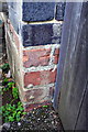
Benchmark on #24 Bowness Avenue
The Ordnance Survey cut mark benchmark which is patly hidden by the gatepost is described on the Bench Mark Database at http://www.bench-marks.org.uk/bm24361
Image: © Roger Templeman
Taken: 18 Sep 2013
0.03 miles
3
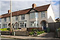
Houses on Bowness Avenue
There is an OS benchmark Image on the side of the right hand house at the junction with its wooden side gate, behind the wheelie bins
Image: © Roger Templeman
Taken: 18 Sep 2013
0.03 miles
4
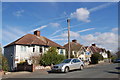
Street scene at Coniston Avenue, Headington
A solitary cable TV pole stands in the street with wires linking some 15 houses along Coniston Avenue. Unlike many streets in the UK today there are no satellite TV dishes to be seen on the houses.
Image: © Roger Davies
Taken: 19 Mar 2008
0.05 miles
5
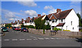
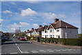
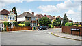
Bowness Avenue, Headington
On the map the street layout of this estate resembles the veins of a leaf.
The streets are named after places in the Lake District and all look very similar.
Check out Image the next street up. (also has info.)
Apart from the name boards it's almost the same scene.
Image: © Des Blenkinsopp
Taken: 23 Jul 2011
0.06 miles
6
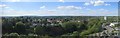
Oxford Panoramic
View of the surrounding area by the Jr hospital in panoramic form
Image: © Bill Nicholls
Taken: 7 Jun 2014
0.07 miles
7
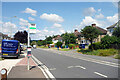
Bowness Avenue Bus Stop
B4495 near John Radcliffe Hospital.
Image: © Des Blenkinsopp
Taken: 3 Aug 2021
0.08 miles
8
Junction of Headley Way and Coniston Avenue
There is an OS benchmark Image on left hand side of the second step up the flight between the lower and upper pavements
Image: © Roger Templeman
Taken: 11 Sep 2015
0.09 miles
9
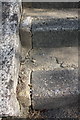
Benchmark on step outside #37 Headley Way
Ordnance Survey rivet benchmark described on the Bench Mark Database at http://www.bench-marks.org.uk/bm70306
Image: © Roger Templeman
Taken: 11 Sep 2015
0.09 miles
10
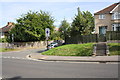
Corner of Ambleside Drive
The junction of Ambleside Drive with Eden Drive, part of an estate developed in the 1950s where all the street names have a Lake District connection.
Image: © Des Blenkinsopp
Taken: 3 Aug 2021
0.09 miles