IMAGES TAKEN NEAR TO
Highbank Close, OXFORD, OX3 0AF
Introduction
This page details the photographs taken nearby to Highbank Close, OX3 0AF by members of the Geograph project.
The Geograph project started in 2005 with the aim of publishing, organising and preserving representative images for every square kilometre of Great Britain, Ireland and the Isle of Man.

There are currently over 7.5m images from over14,400 individuals and you can help contribute to the project by visiting https://www.geograph.org.uk
Image Map
Images are licensed for reuse under creativecommons.org/licenses/by-sa/2.0
Notes
- Clicking on the map will re-center to the selected point.
- The higher the marker number, the further away the image location is from the centre of the postcode.
Image Listing (30 Images Found)
Images are licensed for reuse under creativecommons.org/licenses/by-sa/2.0
Image
Details
Distance
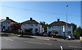
2
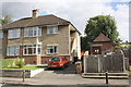
Headley Way at junction of Marston Road
Image: © David Howard
Taken: 29 Jun 2011
0.04 miles
5
Housing and electricity substation on Copse Lane
There is an OS benchmark Image on the entrance to the lower flat of the right hand house
Image: © Roger Templeman
Taken: 18 Sep 2013
0.06 miles
6
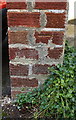
Benchmark at entrance to #50 Copse Lane
Ordnance Survey cut mark benchmark described on the Bench Mark Database at http://www.bench-marks.org.uk/bm51658
Image: © Roger Templeman
Taken: 18 Sep 2013
0.06 miles
7
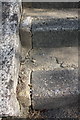
Benchmark on step outside #37 Headley Way
Ordnance Survey rivet benchmark described on the Bench Mark Database at http://www.bench-marks.org.uk/bm70306
Image: © Roger Templeman
Taken: 11 Sep 2015
0.10 miles
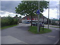
8
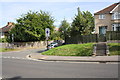
Junction of Headley Way and Coniston Avenue
There is an OS benchmark Image on left hand side of the second step up the flight between the lower and upper pavements
Image: © Roger Templeman
Taken: 11 Sep 2015
0.10 miles
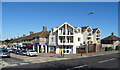
9
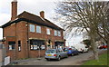
Closed pub on Marston Road at Old Marston Road junction
There is an OS benchmark Image on the side of the building at its near corner
Image: © Roger Templeman
Taken: 24 Mar 2014
0.11 miles
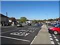
10
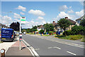
Bowness Avenue Bus Stop
B4495 near John Radcliffe Hospital.
Image: © Des Blenkinsopp
Taken: 3 Aug 2021
0.12 miles