IMAGES TAKEN NEAR TO
West Way Square, OXFORD, OX2 9TJ
Introduction
This page details the photographs taken nearby to West Way Square, OX2 9TJ by members of the Geograph project.
The Geograph project started in 2005 with the aim of publishing, organising and preserving representative images for every square kilometre of Great Britain, Ireland and the Isle of Man.

There are currently over 7.5m images from over14,400 individuals and you can help contribute to the project by visiting https://www.geograph.org.uk
Image Map
Images are licensed for reuse under creativecommons.org/licenses/by-sa/2.0
Notes
- Clicking on the map will re-center to the selected point.
- The higher the marker number, the further away the image location is from the centre of the postcode.
Image Listing (246 Images Found)
Images are licensed for reuse under creativecommons.org/licenses/by-sa/2.0
Image
Details
Distance
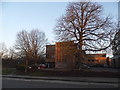
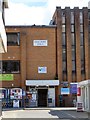
1

Seacourt Hall
Seacourt Hall just off Elms Parade Botley
Image: © Bill Nicholls
Taken: 17 Dec 2009
0.00 miles
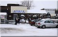
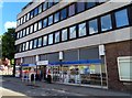
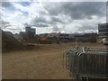
2
Demolition of Botley Precinct
Making way for a new development, Westway Place
https://www.macegroup.com/projects/westway-place
Image: © Stuart Taylor
Taken: 28 Aug 2018
0.01 miles
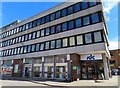
4
Botley Baptist Church in Seacourt Hall
Image: © Steve Daniels
Taken: 26 Apr 2019
0.02 miles
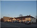
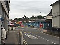
8
Demolition of Botley Precinct to make way for Westway Place development
Image: © Stuart Taylor
Taken: 8 Sep 2018
0.03 miles