IMAGES TAKEN NEAR TO
Homestall Close, OXFORD, OX2 9SW
Introduction
This page details the photographs taken nearby to Homestall Close, OX2 9SW by members of the Geograph project.
The Geograph project started in 2005 with the aim of publishing, organising and preserving representative images for every square kilometre of Great Britain, Ireland and the Isle of Man.

There are currently over 7.5m images from over14,400 individuals and you can help contribute to the project by visiting https://www.geograph.org.uk
Image Map
Images are licensed for reuse under creativecommons.org/licenses/by-sa/2.0
Notes
- Clicking on the map will re-center to the selected point.
- The higher the marker number, the further away the image location is from the centre of the postcode.
Image Listing (14 Images Found)
Images are licensed for reuse under creativecommons.org/licenses/by-sa/2.0
Image
Details
Distance
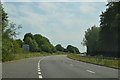
2
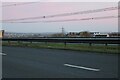
The A420 Botley
Looking south across the town.
Image: © David Howard
Taken: 5 Feb 2023
0.04 miles
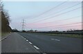
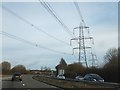
5
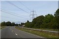
Pylon and cables crossing A420 (Botley by-pass)
Image: © David Smith
Taken: 24 Aug 2017
0.18 miles
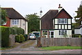
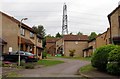
7
Housing estate off, Eynsham Road
Housing estate off, Eynsham Road, viewed from the upper deck of a double-decker bus.
Image: © Philip Halling
Taken: 28 May 2011
0.18 miles

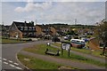
10
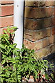
Benchmark on #26 Eynsham Road
Ordnance Survey cut mark benchmark described on the Bench Mark Database at http://www.bench-marks.org.uk/bm39265
Image: © Roger Templeman
Taken: 24 Aug 2011
0.22 miles