IMAGES TAKEN NEAR TO
Forster Lane, OXFORD, OX2 9QR
Introduction
This page details the photographs taken nearby to Forster Lane, OX2 9QR by members of the Geograph project.
The Geograph project started in 2005 with the aim of publishing, organising and preserving representative images for every square kilometre of Great Britain, Ireland and the Isle of Man.

There are currently over 7.5m images from over14,400 individuals and you can help contribute to the project by visiting https://www.geograph.org.uk
Image Map
Images are licensed for reuse under creativecommons.org/licenses/by-sa/2.0
Notes
- Clicking on the map will re-center to the selected point.
- The higher the marker number, the further away the image location is from the centre of the postcode.
Image Listing (46 Images Found)
Images are licensed for reuse under creativecommons.org/licenses/by-sa/2.0
Image
Details
Distance

6
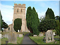
St Michaels Church, Cumnor
Cumnor near Oxford is a beautiful village with thatched cottages. Near to Eaton Image and Appleton Image
Image: © Alison Stamp
Taken: 5 Sep 2005
0.15 miles
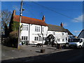
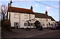
10
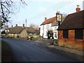
The Vine Inn, Cumnor
Image: © Jonathan Billinger
Taken: 19 Dec 2007
0.17 miles