IMAGES TAKEN NEAR TO
Meadow Close, OXFORD, OX2 9PA
Introduction
This page details the photographs taken nearby to Meadow Close, OX2 9PA by members of the Geograph project.
The Geograph project started in 2005 with the aim of publishing, organising and preserving representative images for every square kilometre of Great Britain, Ireland and the Isle of Man.

There are currently over 7.5m images from over14,400 individuals and you can help contribute to the project by visiting https://www.geograph.org.uk
Image Map
Images are licensed for reuse under creativecommons.org/licenses/by-sa/2.0
Notes
- Clicking on the map will re-center to the selected point.
- The higher the marker number, the further away the image location is from the centre of the postcode.
Image Listing (25 Images Found)
Images are licensed for reuse under creativecommons.org/licenses/by-sa/2.0
Image
Details
Distance

2
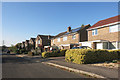
Houses in Meadow Close, Farmoor
Farmoor is a village of mostly recent housing with a suburban look to it.
Image: © Des Blenkinsopp
Taken: 12 Oct 2015
0.02 miles


5
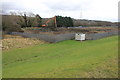
Excavating at Farmoor Reservoir
This long armed excavator was cleaning water channels at the northern end of the reservoir. In the foreground is the dam retaining the water in the reservoir.
Image: © Nigel Mykura
Taken: 26 Feb 2017
0.06 miles


10
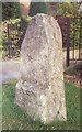
Old Milestone by the B4044, Oxford Road, Farmoor
Carved stone post by the B4044, in parish of CUMNOR (VALE OF WHITE HORSE District), Oxford Road, Farmoor, outside No.2, on lawn in front of garden fence of a bungalow, on North side of road. Botley tombstone, erected by the Botley & Newland turnpike trust in the 19th century.
Inscription reads:-
WITNEY
7
OXFORD
4
Carved benchmark bottom face.
Grade II Listed. List Entry Number: 1181978
https://historicengland.org.uk/listing/the-list/list-entry/1181978
Milestone Society National ID: BE_LGOx62.
Image: © A Rosevear
Taken: 4 Oct 2001
0.09 miles