IMAGES TAKEN NEAR TO
Lower Whitley Road, OXFORD, OX2 9NU
Introduction
This page details the photographs taken nearby to Lower Whitley Road, OX2 9NU by members of the Geograph project.
The Geograph project started in 2005 with the aim of publishing, organising and preserving representative images for every square kilometre of Great Britain, Ireland and the Isle of Man.

There are currently over 7.5m images from over14,400 individuals and you can help contribute to the project by visiting https://www.geograph.org.uk
Image Map
Images are licensed for reuse under creativecommons.org/licenses/by-sa/2.0
Notes
- Clicking on the map will re-center to the selected point.
- The higher the marker number, the further away the image location is from the centre of the postcode.
Image Listing (24 Images Found)
Images are licensed for reuse under creativecommons.org/licenses/by-sa/2.0
Image
Details
Distance
1
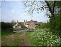
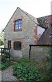
Tumbledown Cottage, Filchampstead
Not a comment on the state of the place, that's the name of the house.
One of the handful of residences in the hamlet of Filchampstead.
The footpath is the Oxford Green Belt Way http://www.gps-routes.co.uk/routes/home.nsf/routeslinkswalks/oxford-green-belt-way-walking-route
Image: © Des Blenkinsopp
Taken: 30 Apr 2014
0.05 miles
2
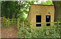
Toilets by the footpath
The Countryside Walk stretches for 4.5 miles around Farmoor Reservoir.
Image: © Steve Daniels
Taken: 17 Aug 2013
0.05 miles
3
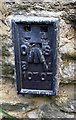
Benchmark on Tumbledown Cottage
Ordnance Survey flush bracket (serial number 10707) benchmark described on the Bench Mark Database at http://www.bench-marks.org.uk/bm21989
Image: © Roger Templeman
Taken: 9 Oct 2015
0.05 miles
4
'Tumbledown Cottage', Tumbledown Hill
There is an OS flush bracket Image set into the wall right of the black downpipe
Image: © Roger Templeman
Taken: 9 Oct 2015
0.05 miles
5
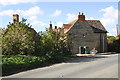
'Tumbledown Cottage', Cumnor Hill
The building on the left hand side of the image carries the name 'The Dog House'.
Image: © Roger Templeman
Taken: 9 Oct 2015
0.05 miles
6

An information panel on the Countryside Walk
The Countryside Walk stretches for 4.5 miles around Farmoor Reservoir.
Image: © Steve Daniels
Taken: 17 Aug 2013
0.06 miles
7
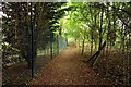
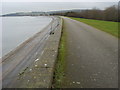
The footpath around Farmoor Reservoir
The Countryside Walk stretches for 4.5 miles around Farmoor Reservoir.
Image: © Steve Daniels
Taken: 17 Aug 2013
0.09 miles
8
The footpath by Farmoor Reservoir
The Countryside Walk stretches for 4.5 miles around Farmoor Reservoir.
Image: © Steve Daniels
Taken: 17 Aug 2013
0.09 miles
9
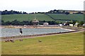
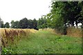
Farmoor Reservoir
Farmoor Reservoir II
Image: © Shaun Ferguson
Taken: 30 Dec 2009
0.11 miles