IMAGES TAKEN NEAR TO
Nobles Lane, OXFORD, OX2 9NF
Introduction
This page details the photographs taken nearby to Nobles Lane, OX2 9NF by members of the Geograph project.
The Geograph project started in 2005 with the aim of publishing, organising and preserving representative images for every square kilometre of Great Britain, Ireland and the Isle of Man.

There are currently over 7.5m images from over14,400 individuals and you can help contribute to the project by visiting https://www.geograph.org.uk
Image Map
Images are licensed for reuse under creativecommons.org/licenses/by-sa/2.0
Notes
- Clicking on the map will re-center to the selected point.
- The higher the marker number, the further away the image location is from the centre of the postcode.
Image Listing (32 Images Found)
Images are licensed for reuse under creativecommons.org/licenses/by-sa/2.0
Image
Details
Distance
1
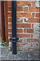
Benchmark on #1 Nobles Farm Cottages
Ordnance Survey cut mark benchmark described on the Bench Mark Database at http://www.bench-marks.org.uk/bm70871
Image: © Roger Templeman
Taken: 9 Oct 2015
0.00 miles
2
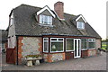
#1 Nobles Farm Cottages
There is an OS benchmark Image on the front of the house, left hand corner, right of the black downpipe
Image: © Roger Templeman
Taken: 9 Oct 2015
0.01 miles
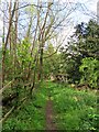
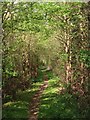
9
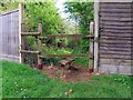
A stile on the footpath to Dean Court
Image: © Steve Daniels
Taken: 26 Apr 2019
0.09 miles