IMAGES TAKEN NEAR TO
Seacourt Road, OXFORD, OX2 9LD
Introduction
This page details the photographs taken nearby to Seacourt Road, OX2 9LD by members of the Geograph project.
The Geograph project started in 2005 with the aim of publishing, organising and preserving representative images for every square kilometre of Great Britain, Ireland and the Isle of Man.

There are currently over 7.5m images from over14,400 individuals and you can help contribute to the project by visiting https://www.geograph.org.uk
Image Map
Images are licensed for reuse under creativecommons.org/licenses/by-sa/2.0
Notes
- Clicking on the map will re-center to the selected point.
- The higher the marker number, the further away the image location is from the centre of the postcode.
Image Listing (71 Images Found)
Images are licensed for reuse under creativecommons.org/licenses/by-sa/2.0
Image
Details
Distance
1
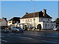
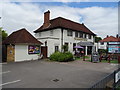
The Seacourt Bridge
The Seacourt Bridge public house in Botley.
Image: © Bill Nicholls
Taken: 17 Dec 2009
0.05 miles
2
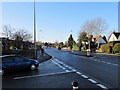
Junction on the road
The road junction at Elms Parade where shoppers feed back in to the Westway traffic.
Image: © Bill Nicholls
Taken: 17 Dec 2009
0.06 miles
3
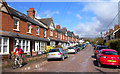
Poplar Road, Botley
An unadopted gravel surfaced road on the edge of town, leading up to fields.
Image: © Des Blenkinsopp
Taken: 17 Apr 2012
0.06 miles


8
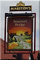
Sign for the Seacourt Bridge, Botley
See Image] for context.
Image: © JThomas
Taken: 15 Jul 2019
0.07 miles
9
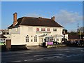
The Seacourt Bridge pub
View of the Seacourt Bridge pub opposite Elms Parade, Botley.
Image: © Bill Nicholls
Taken: 17 Dec 2009
0.07 miles
10
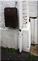
Partly hidden benchmark on #76 West Way
Ordnance Survey cut mark benchmark levelled at 62.130m above mean sea level
Image: © Roger Templeman
Taken: 14 Mar 2018
0.08 miles