IMAGES TAKEN NEAR TO
Hurst Rise Road, OXFORD, OX2 9HQ
Introduction
This page details the photographs taken nearby to Hurst Rise Road, OX2 9HQ by members of the Geograph project.
The Geograph project started in 2005 with the aim of publishing, organising and preserving representative images for every square kilometre of Great Britain, Ireland and the Isle of Man.

There are currently over 7.5m images from over14,400 individuals and you can help contribute to the project by visiting https://www.geograph.org.uk
Image Map
Images are licensed for reuse under creativecommons.org/licenses/by-sa/2.0
Notes
- Clicking on the map will re-center to the selected point.
- The higher the marker number, the further away the image location is from the centre of the postcode.
Image Listing (20 Images Found)
Images are licensed for reuse under creativecommons.org/licenses/by-sa/2.0
Image
Details
Distance
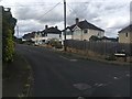
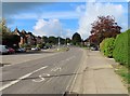
5
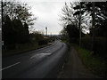
Cumnor Hill
Looking north east down Cumnor Hill towards Botley. A quiet scene on Boxing Day.
Image: © Peter Jordan
Taken: 26 Dec 2005
0.14 miles
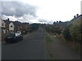
8
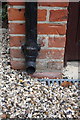
Benchmark on garage of #36 Cumnor Hill
Ordnance Survey cut mark benchmark described on the Bench Mark Database at http://www.bench-marks.org.uk/bm70478
Image: © Roger Templeman
Taken: 23 Sep 2015
0.21 miles
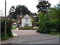
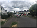
10
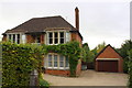
#36 Cumnor Hill with detached garage
There is an OS benchmark Image on the bricks on the left hand side of the garage door by the downpipe
Image: © Roger Templeman
Taken: 23 Sep 2015
0.22 miles