IMAGES TAKEN NEAR TO
Thackeray Close, OXFORD, OX2 9GZ
Introduction
This page details the photographs taken nearby to Thackeray Close, OX2 9GZ by members of the Geograph project.
The Geograph project started in 2005 with the aim of publishing, organising and preserving representative images for every square kilometre of Great Britain, Ireland and the Isle of Man.

There are currently over 7.5m images from over14,400 individuals and you can help contribute to the project by visiting https://www.geograph.org.uk
Image Map
Images are licensed for reuse under creativecommons.org/licenses/by-sa/2.0
Notes
- Clicking on the map will re-center to the selected point.
- The higher the marker number, the further away the image location is from the centre of the postcode.
Image Listing (17 Images Found)
Images are licensed for reuse under creativecommons.org/licenses/by-sa/2.0
Image
Details
Distance
1
Breeches End
Unusual roofline on this property on Cumnor Hill.
Unusual name too.
Image: © Des Blenkinsopp
Taken: 17 Apr 2012
0.10 miles
2
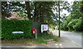
Cumnor Hill
Showing position of Postbox No. OX2 290.
See Image] for postbox.
Image: © JThomas
Taken: 15 Jul 2019
0.12 miles
3
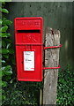
Elizabeth II postbox on Cumnor Hill
Postbox No. OX2 290.
See Image] for context.
Image: © JThomas
Taken: 15 Jul 2019
0.12 miles
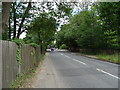
5
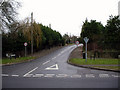
Junction of Cumnor Hill and Arnolds Way
A very quiet Boxing Day scene in the upmarket Oxford suburb of Cumnor Hill.
Image: © Peter Jordan
Taken: 26 Dec 2005
0.14 miles
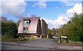
6

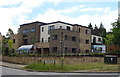
Barn Close, Cumnor Hill
A brand new development, but featuring many retro style details which exactly mimic some of the large and prosperous early 20C residences to be found nearby.
Image: © Des Blenkinsopp
Taken: 17 Apr 2012
0.14 miles
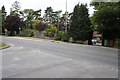
7

Cumnor Parish Council Information Board in Arnold's Way
Image: © Steve Daniels
Taken: 27 Sep 2009
0.14 miles
8
Cumnor Hill at entrance to 'Milestone House'
The Ordnance Survey cut a benchmark (see http://www.bench-marks.org.uk/bm20336 ) in 1856 on a milestone (2 miles from Oxford) on the far side of the road outside the present 'Milestone House'. The stone has since been lost but the house retains its name.
Image: © Roger Templeman
Taken: 23 Sep 2015
0.14 miles
9
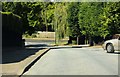
Arnold's Way leading down to Cumnor Hill
Image: © Steve Daniels
Taken: 27 Sep 2009
0.16 miles