IMAGES TAKEN NEAR TO
Cumnor Hill, OXFORD, OX2 9EU
Introduction
This page details the photographs taken nearby to Cumnor Hill, OX2 9EU by members of the Geograph project.
The Geograph project started in 2005 with the aim of publishing, organising and preserving representative images for every square kilometre of Great Britain, Ireland and the Isle of Man.

There are currently over 7.5m images from over14,400 individuals and you can help contribute to the project by visiting https://www.geograph.org.uk
Image Map
Images are licensed for reuse under creativecommons.org/licenses/by-sa/2.0
Notes
- Clicking on the map will re-center to the selected point.
- The higher the marker number, the further away the image location is from the centre of the postcode.
Image Listing (51 Images Found)
Images are licensed for reuse under creativecommons.org/licenses/by-sa/2.0
Image
Details
Distance
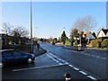
2
Parting of ways
A view of the busy road junction that takes you to Witney via Eynsham. The main road to the left takes you up Cumnor hill and the one to the right Eynsham and the dreaded toll bridge. I might add the Eynsham road is more of a rat run and in the rush hours can be backed up for miles.
Image: © Bill Nicholls
Taken: 17 Dec 2009
0.09 miles
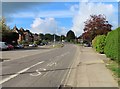
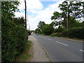
5
Road to Cumnor
Take the road here to get to Cumnor. At one time this was the A420 a very busy road till they built the bypass. It is still the main artery from Witney to Oxford.
Image: © Bill Nicholls
Taken: 17 Dec 2009
0.10 miles
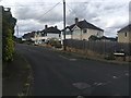
7
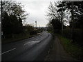
Cumnor Hill
Looking north east down Cumnor Hill towards Botley. A quiet scene on Boxing Day.
Image: © Peter Jordan
Taken: 26 Dec 2005
0.12 miles
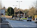
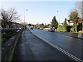
8
Junction on the road
The road junction at Elms Parade where shoppers feed back in to the Westway traffic.
Image: © Bill Nicholls
Taken: 17 Dec 2009
0.13 miles
10
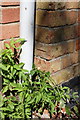
Benchmark on #26 Eynsham Road
Ordnance Survey cut mark benchmark described on the Bench Mark Database at http://www.bench-marks.org.uk/bm39265
Image: © Roger Templeman
Taken: 24 Aug 2011
0.13 miles