IMAGES TAKEN NEAR TO
Lime Road, OXFORD, OX2 9EQ
Introduction
This page details the photographs taken nearby to Lime Road, OX2 9EQ by members of the Geograph project.
The Geograph project started in 2005 with the aim of publishing, organising and preserving representative images for every square kilometre of Great Britain, Ireland and the Isle of Man.

There are currently over 7.5m images from over14,400 individuals and you can help contribute to the project by visiting https://www.geograph.org.uk
Image Map
Images are licensed for reuse under creativecommons.org/licenses/by-sa/2.0
Notes
- Clicking on the map will re-center to the selected point.
- The higher the marker number, the further away the image location is from the centre of the postcode.
Image Listing (8 Images Found)
Images are licensed for reuse under creativecommons.org/licenses/by-sa/2.0
Image
Details
Distance
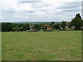
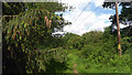
3
Play area, Louie Memorial Playing Fields
Image: © Alex McGregor
Taken: 14 Aug 2013
0.12 miles

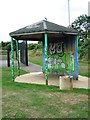
6

Graffiti covered changing rooms off Arnold's Way
Image: © Steve Daniels
Taken: 27 Sep 2009
0.15 miles
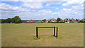
7
Harcourt Hill Campus
This isn't an official public footpath along here, but owners Oxford Brookes University are pleasantly relaxed about access.
Image: © Des Blenkinsopp
Taken: 24 May 2011
0.23 miles
8
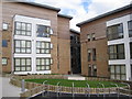
Westminster Hall, Harcourt Hill Campus
This is a new hall of residence at the Oxford Brookes University Harcourt Hill Campus. http://www.brookes.ac.uk/studying/accommodation/halls/westminsterhall
Image: © Chris Holifield
Taken: 31 Aug 2012
0.23 miles