IMAGES TAKEN NEAR TO
Orchard Road, OXFORD, OX2 9BH
Introduction
This page details the photographs taken nearby to Orchard Road, OX2 9BH by members of the Geograph project.
The Geograph project started in 2005 with the aim of publishing, organising and preserving representative images for every square kilometre of Great Britain, Ireland and the Isle of Man.

There are currently over 7.5m images from over14,400 individuals and you can help contribute to the project by visiting https://www.geograph.org.uk
Image Map
Images are licensed for reuse under creativecommons.org/licenses/by-sa/2.0
Notes
- Clicking on the map will re-center to the selected point.
- The higher the marker number, the further away the image location is from the centre of the postcode.
Image Listing (28 Images Found)
Images are licensed for reuse under creativecommons.org/licenses/by-sa/2.0
Image
Details
Distance
2

St Andrew's Church
A wooden structure in which local events are also held, in addition to services.
Image: © Jackie Bowman
Taken: 8 Jan 2007
0.07 miles

6
A stile on the footpath to Dean Court
Image: © Steve Daniels
Taken: 26 Apr 2019
0.11 miles
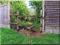
10
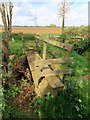
Stiles over a drain on the footpath to Farmoor
Image: © Steve Daniels
Taken: 26 Apr 2019
0.15 miles