IMAGES TAKEN NEAR TO
Delawarr Court, Raleigh Park Road, OXFORD, OX2 9AR
Introduction
This page details the photographs taken nearby to Delawarr Court, Raleigh Park Road, OX2 9AR by members of the Geograph project.
The Geograph project started in 2005 with the aim of publishing, organising and preserving representative images for every square kilometre of Great Britain, Ireland and the Isle of Man.

There are currently over 7.5m images from over14,400 individuals and you can help contribute to the project by visiting https://www.geograph.org.uk
Image Map
Images are licensed for reuse under creativecommons.org/licenses/by-sa/2.0
Notes
- Clicking on the map will re-center to the selected point.
- The higher the marker number, the further away the image location is from the centre of the postcode.
Image Listing (9 Images Found)
Images are licensed for reuse under creativecommons.org/licenses/by-sa/2.0
Image
Details
Distance
1
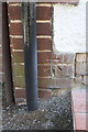
Benchmark on #184 Westminster Way
Ordnance Survey cut mark benchmark described on the Bench Mark Database at http://www.bench-marks.org.uk/bm39262
Image: © Roger Templeman
Taken: 24 Aug 2011
0.12 miles
2
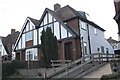
Nos. 184 and 186 Westminster Way
There is an OS benchmark Image on the side of the near house, No. 184
Image: © Roger Templeman
Taken: 24 Aug 2011
0.12 miles
3

Our Lady Of The Rosary Catholic Church in Botley
Image: © Steve Daniels
Taken: 27 Sep 2009
0.15 miles
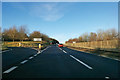
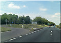
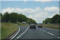
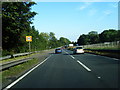
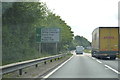
8
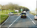
A34 Oxford Bypass
The turnoff for Harcourt Hill.
Image: © David Dixon
Taken: 21 Dec 2012
0.22 miles