IMAGES TAKEN NEAR TO
Crawley, WITNEY, OX29 9XS
Introduction
This page details the photographs taken nearby to OX29 9XS by members of the Geograph project.
The Geograph project started in 2005 with the aim of publishing, organising and preserving representative images for every square kilometre of Great Britain, Ireland and the Isle of Man.

There are currently over 7.5m images from over14,400 individuals and you can help contribute to the project by visiting https://www.geograph.org.uk
Image Map
Images are licensed for reuse under creativecommons.org/licenses/by-sa/2.0
Notes
- Clicking on the map will re-center to the selected point.
- The higher the marker number, the further away the image location is from the centre of the postcode.
Image Listing (12 Images Found)
Images are licensed for reuse under creativecommons.org/licenses/by-sa/2.0
Image
Details
Distance
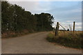
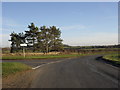
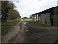
1
Road to Hailey
Just north of Crawley. Buildings at Broken Hatch Farm can be seen behind the trees to the right.
Image: © andrew auger
Taken: 24 Oct 2009
0.02 miles
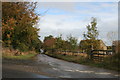
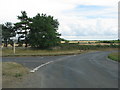
2
Junction near Crawley
At the top of the rise out of the village
Image: © andrew auger
Taken: 3 Jan 2009
0.06 miles
4
Entrance to a foggy Crawley on Leafield Road
There is a dry stone wall hidden in the brambles on the left hand side of the image
Image: © Roger Templeman
Taken: 25 Jan 2017
0.07 miles
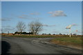
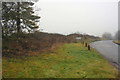
7
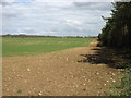
Fields at Broken Hatch Farm
North of Crawley and west of Hailey.
Image: © David Purchase
Taken: 19 Apr 2013
0.13 miles
8
Lane to Middletown
Lane to Middletown by Broken Hatch Farm
Image: © Shaun Ferguson
Taken: 22 Jan 2012
0.15 miles
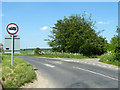
9

Leafield Road
Leafield Road passing drive and footpath down to The Courtyard and Uphill Farm
Image: © Shaun Ferguson
Taken: 22 Jan 2012
0.17 miles