IMAGES TAKEN NEAR TO
Priest Hill Lane, WITNEY, OX29 9TT
Introduction
This page details the photographs taken nearby to Priest Hill Lane, OX29 9TT by members of the Geograph project.
The Geograph project started in 2005 with the aim of publishing, organising and preserving representative images for every square kilometre of Great Britain, Ireland and the Isle of Man.

There are currently over 7.5m images from over14,400 individuals and you can help contribute to the project by visiting https://www.geograph.org.uk
Image Map (Loading...)


Getting Data...Please wait
Leaflet Map data © OpenStreetMap
Images are licensed for reuse under creativecommons.org/licenses/by-sa/2.0
Notes
- Clicking on the map will re-center to the selected point.
- The higher the marker number, the further away the image location is from the centre of the postcode.
Image Listing (22 Images Found)
Images are licensed for reuse under creativecommons.org/licenses/by-sa/2.0
Image
Details
Distance
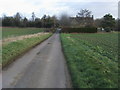
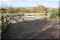
2
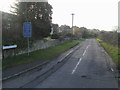
Priest Hill Lane
Priest Hill Lane heading to Crawley
Image: © Shaun Ferguson
Taken: 22 Jan 2012
0.03 miles
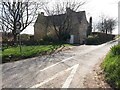
4
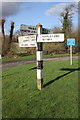
Signpost at crossroads beside B4020 at Delly Hill
Image: © Roger Templeman
Taken: 10 Feb 2016
0.05 miles
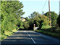
5
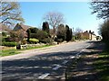
Nearing the main road into Middletown
Lane from Broken Hatch Farm nearing the main road into Middletown
Image: © Shaun Ferguson
Taken: 22 Jan 2012
0.11 miles
7
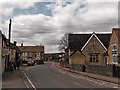
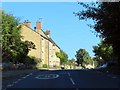
School and houses in Middletown, Hailey
Image: © Chris Brown
Taken: 16 Apr 2018
0.13 miles
9
Priest Hill (Hailey) sewage pumping station
Image: © Roger Templeman
Taken: 10 Feb 2016
0.13 miles
10
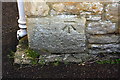
Benchmark on Hailey Primary School
Ordnance Survey cut mark benchmark described on the Bench Mark Database at http://www.bench-marks.org.uk/bm73474
Image: © Roger Templeman
Taken: 10 Feb 2016
0.14 miles