IMAGES TAKEN NEAR TO
Dry Lane, WITNEY, OX29 9SU
Introduction
This page details the photographs taken nearby to Dry Lane, OX29 9SU by members of the Geograph project.
The Geograph project started in 2005 with the aim of publishing, organising and preserving representative images for every square kilometre of Great Britain, Ireland and the Isle of Man.

There are currently over 7.5m images from over14,400 individuals and you can help contribute to the project by visiting https://www.geograph.org.uk
Image Map (Loading...)


Getting Data...Please wait
Leaflet Map data © OpenStreetMap
Images are licensed for reuse under creativecommons.org/licenses/by-sa/2.0
Notes
- Clicking on the map will re-center to the selected point.
- The higher the marker number, the further away the image location is from the centre of the postcode.
Image Listing (13 Images Found)
Images are licensed for reuse under creativecommons.org/licenses/by-sa/2.0
Image
Details
Distance
1
Crawley Mill (ex-Blanket Mill) by River Windrush
Image: © Paul Thomas
Taken: 22 Apr 2007
0.03 miles
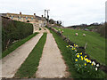
2

River Windrush
Looking upstream from Crawley Bridge.
Image: © Jonathan Billinger
Taken: 23 Jan 2007
0.04 miles
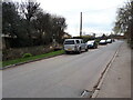
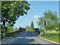
3

Traffic lights at the bridge
Entering Crawley
Image: © andrew auger
Taken: 3 Jan 2009
0.09 miles
4
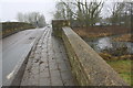
Crawley Bridge taking Dry Lane over River Windrush
There is an OS benchmark Image at the base of the curved near end of the right hand parapet where it meets the abutting wall
Image: © Roger Templeman
Taken: 25 Jan 2017
0.09 miles
5
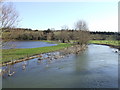
River Windrush in flood
Looking downstream from Crawley Bridge.
Image: © Jonathan Billinger
Taken: 23 Jan 2007
0.09 miles
6
Crawley Bridge
Dry Lane crosses the River Windrush.
Image: © Robin Webster
Taken: 18 May 2014
0.10 miles
7
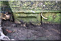
Partly-buried benchmark on Crawley Bridge
Ordnance Survey cut mark benchmark described on the Bench Mark Database at http://www.bench-marks.org.uk/bm81727
Image: © Roger Templeman
Taken: 25 Jan 2017
0.10 miles
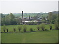
8
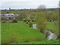
River Windrush near Crawley
Crawley bridge and Crawley Mill visible in the distance. Crawley Mill was originally involved in the blanket making industry of the area.
Image: © Bikeboy
Taken: 7 Apr 2014
0.13 miles