IMAGES TAKEN NEAR TO
The Ridings, WITNEY, OX29 9NH
Introduction
This page details the photographs taken nearby to The Ridings, OX29 9NH by members of the Geograph project.
The Geograph project started in 2005 with the aim of publishing, organising and preserving representative images for every square kilometre of Great Britain, Ireland and the Isle of Man.

There are currently over 7.5m images from over14,400 individuals and you can help contribute to the project by visiting https://www.geograph.org.uk
Image Map (Loading...)


Getting Data...Please wait
Leaflet Map data © OpenStreetMap
Images are licensed for reuse under creativecommons.org/licenses/by-sa/2.0
Notes
- Clicking on the map will re-center to the selected point.
- The higher the marker number, the further away the image location is from the centre of the postcode.
Image Listing (7 Images Found)
Images are licensed for reuse under creativecommons.org/licenses/by-sa/2.0
Image
Details
Distance
1
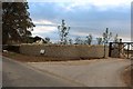
The new entrance to Lowbarrow Farm, Fordwells
Image: © David Howard
Taken: 12 Sep 2019
0.02 miles
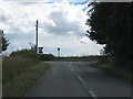
5
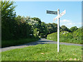
Country lane junction
The timeless aspect of the view is marred by the finger pointing straight on to Leafield Technical Centre.
Image: © Robin Webster
Taken: 18 May 2014
0.18 miles
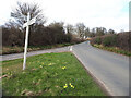
6
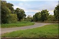
Green triangle junction in Field Assarts
Image: © David Howard
Taken: 12 Sep 2019
0.20 miles
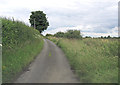
7
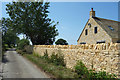
New Stone Wall, Purrants Lane
Freshly quarried Cotswold stone is this bright, light colour. After a few years weathering it settles down to a more subdued look.
Image: © Des Blenkinsopp
Taken: 23 Jun 2020
0.24 miles