IMAGES TAKEN NEAR TO
Slate Crescent, WITNEY, OX29 8FG
Introduction
This page details the photographs taken nearby to Slate Crescent, OX29 8FG by members of the Geograph project.
The Geograph project started in 2005 with the aim of publishing, organising and preserving representative images for every square kilometre of Great Britain, Ireland and the Isle of Man.

There are currently over 7.5m images from over14,400 individuals and you can help contribute to the project by visiting https://www.geograph.org.uk
Image Map (Loading...)


Getting Data...Please wait
Leaflet Map data © OpenStreetMap
Images are licensed for reuse under creativecommons.org/licenses/by-sa/2.0
Notes
- Clicking on the map will re-center to the selected point.
- The higher the marker number, the further away the image location is from the centre of the postcode.
Image Listing (15 Images Found)
Images are licensed for reuse under creativecommons.org/licenses/by-sa/2.0
Image
Details
Distance
1
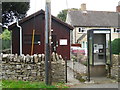
Stonesfield Telephone Exchange, Oxon (1)
Situated in Combe Road, this TE is a wooden-type hut building common in rural areas. A KX200 telephone kiosk can be seen in front of it with a modern payphone although it says that coins are not accepted here above it. Update: the KX200 telephone kiosk has since been removed from this location.
Image: © David Hillas
Taken: 8 Oct 2016
0.11 miles
2
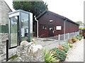
Stonesfield Telephone Exchange, Oxon (2)
Situated in Combe Road, this TE serves Stonesfield plus Combe and Fawler nearby. A KX200 telephone kiosk can be seen in front of it with the former BT Piper logo inscribed on its sides. This TE has the numbering range (01993) 891xxx, 898xxx, the (01993) referring to the Witney group of TEs, and its postcode is OX29 8QB.
Update: the KX200 telephone kiosk has since been removed from this location.
Image: © David Hillas
Taken: 8 Oct 2016
0.11 miles
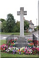
3
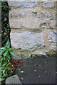
Benchmark on cottage at Combe Road junction
Ordnance Survey cut mark benchmark described on the Bench Mark Database at http://www.bench-marks.org.uk/bm61979
Image: © Roger Templeman
Taken: 15 Nov 2014
0.13 miles
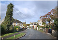
4
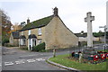
Houses and war memorial beside Combe Road
There is an OS benchmark Image above the pavement end on the near corner of the house
Image: © Roger Templeman
Taken: 15 Nov 2014
0.13 miles
8
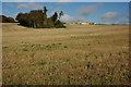
Stubble field at Stonesfield
A stubble field and houses at Stonesfield viewed from the Oxfordshire Way.
Image: © Philip Halling
Taken: 18 Oct 2008
0.16 miles
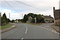
9
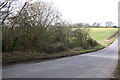
The road into Stonesfield from Combe
On the left is a ruined dry stone wall, and the Wychwood Way footpath crosses the road at the far end of the wood
Image: © Roger Templeman
Taken: 29 Feb 2016
0.21 miles