IMAGES TAKEN NEAR TO
Combe, WITNEY, OX29 8EW
Introduction
This page details the photographs taken nearby to OX29 8EW by members of the Geograph project.
The Geograph project started in 2005 with the aim of publishing, organising and preserving representative images for every square kilometre of Great Britain, Ireland and the Isle of Man.

There are currently over 7.5m images from over14,400 individuals and you can help contribute to the project by visiting https://www.geograph.org.uk
Image Map (Loading...)


Getting Data...Please wait
Leaflet Map data © OpenStreetMap
Images are licensed for reuse under creativecommons.org/licenses/by-sa/2.0
Notes
- Clicking on the map will re-center to the selected point.
- The higher the marker number, the further away the image location is from the centre of the postcode.
Image Listing (12 Images Found)
Images are licensed for reuse under creativecommons.org/licenses/by-sa/2.0
Image
Details
Distance
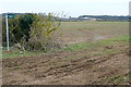
2
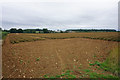
A field of cherry tomatoes
Looking towards Akeman Street Farm, to which this field belongs.
Image: © Bill Boaden
Taken: 20 Aug 2015
0.18 miles
4
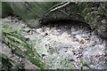
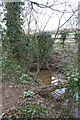
Benchmark on Akeman Street culvert
Ordnance Survey rivet benchmark described on the Bench Mark Database at http://www.bench-marks.org.uk/bm73834
Image: © Roger Templeman
Taken: 29 Feb 2016
0.19 miles
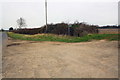
5
Culvert at wall / fence junction beside Akeman Street
There is an OS benchmark Image on top of the culvert
Image: © Roger Templeman
Taken: 29 Feb 2016
0.19 miles
6
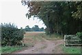
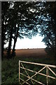
Field entrance by Akeman Street, Combe
Image: © David Howard
Taken: 12 Sep 2019
0.19 miles
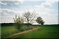
7
Akeman Street
The Roman Road Akeman Street is now used by this footpath, the Oxfordshire Way. But we are walking Shakespeare's Way, another long distance route, that does not go this way but turns left here onto the path heading in the opposite direction.
Image: © Graham Horn
Taken: 24 Feb 2013
0.20 miles
8

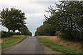
Beech tree on the Oxfordshire Way
The Oxfordshire Way follows the course of Akeman Street, a Roman road connecting Cirencester with London. See: http://en.wikipedia.org/wiki/Akeman_Street
Image: © Philip Halling
Taken: 18 Oct 2008
0.20 miles
9
Wychwood Way crosses Akeman Street
There is a dry stone wall buried in hedgerow at the far side of the junction
Image: © Roger Templeman
Taken: 29 Feb 2016
0.21 miles
10
Akeman Street, Oxfordshire Way
The Oxfordshire Way path follows the route of the Roman road Akeman Street WSW towards next crossing a road at Image
Image: © SA Mathieson
Taken: 29 Apr 2006
0.22 miles