IMAGES TAKEN NEAR TO
The Ridings, WITNEY, OX29 8EB
Introduction
This page details the photographs taken nearby to The Ridings, OX29 8EB by members of the Geograph project.
The Geograph project started in 2005 with the aim of publishing, organising and preserving representative images for every square kilometre of Great Britain, Ireland and the Isle of Man.

There are currently over 7.5m images from over14,400 individuals and you can help contribute to the project by visiting https://www.geograph.org.uk
Image Map
Images are licensed for reuse under creativecommons.org/licenses/by-sa/2.0
Notes
- Clicking on the map will re-center to the selected point.
- The higher the marker number, the further away the image location is from the centre of the postcode.
Image Listing (12 Images Found)
Images are licensed for reuse under creativecommons.org/licenses/by-sa/2.0
Image
Details
Distance
2
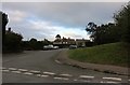
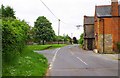
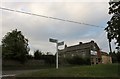
The Ridings, Stonesfield, Oxon
Further on the road becomes Stonesfield Riding. It continues out of the village and later it forms a T-junction with the B4437 road.
Image: © P L Chadwick
Taken: 30 May 2016
0.04 miles
3
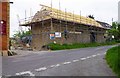
Former function room of the White Horse Inn, The Ridings, Stonesfield, Oxon
For many years this building served as a function room for the adjacent White Horse Inn. The building is currently undergoing conversion to residential use, but the pub will continue to operate.
Image
Image: © P L Chadwick
Taken: 30 May 2016
0.07 miles
4
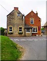
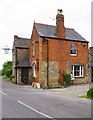
The White Horse Inn (1), The Ridings, Stonesfield, Oxon
Following the closure of the Black Head (formerly the Black Boy) some time ago, this is the last functioning public house in the village. The building dates from the 19th century. This free house is near the northern edge of the village. It is currently undergoing improvements but remains open except on Mondays and Sunday evenings. The village does also possess a sports & social club with bar.
Image
Image
Image
Image: © P L Chadwick
Taken: 30 May 2016
0.08 miles
5
The White Horse Inn (2), The Ridings, Stonesfield, Oxon
The last surviving public house in a village which years ago had many.
Other photos:- Image
Image: © P L Chadwick
Taken: 30 May 2016
0.08 miles
6
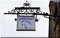
The White Horse Inn (3) - sign, The Ridings, Stonesfield, Oxon
Public houses and inns were often given names which could be easily illustrated on the sign and identified by people who in days gone by often could not read or write. The White Horse is one of the most popular pub names.
Other photos:- Image
Image: © P L Chadwick
Taken: 30 May 2016
0.08 miles
7
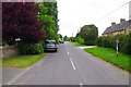
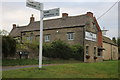
Junction of Pond Hill and The Ridings, Stonesfield, Oxon
Pond Hill is the road on the left.
Image: © P L Chadwick
Taken: 30 May 2016
0.09 miles
10
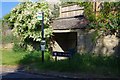
Bus stop and shelter, The Ridings, Stonesfield, Oxon
The vegetation is taking over here. No doubt the current Coronavirus pandemic has brought grass cutting etc. to a temporary halt.
Image: © P L Chadwick
Taken: 30 May 2020
0.22 miles