IMAGES TAKEN NEAR TO
Blenheim Lane, WITNEY, OX29 8AW
Introduction
This page details the photographs taken nearby to Blenheim Lane, OX29 8AW by members of the Geograph project.
The Geograph project started in 2005 with the aim of publishing, organising and preserving representative images for every square kilometre of Great Britain, Ireland and the Isle of Man.

There are currently over 7.5m images from over14,400 individuals and you can help contribute to the project by visiting https://www.geograph.org.uk
Image Map
Images are licensed for reuse under creativecommons.org/licenses/by-sa/2.0
Notes
- Clicking on the map will re-center to the selected point.
- The higher the marker number, the further away the image location is from the centre of the postcode.
Image Listing (30 Images Found)
Images are licensed for reuse under creativecommons.org/licenses/by-sa/2.0
Image
Details
Distance
1
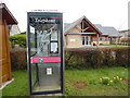
KX100 Phone Box in Wroslyn Road, Freeland
Situated in Wroslyn Road, this photo shows a KX100 phone box with a wooden bus shelter just visible on the left of the photo. In the background can be seen Freeland Village Hall whose postcode is OX29 8AL.
Image: © David Hillas
Taken: 5 Mar 2016
0.06 miles
2
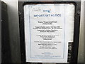
BT Notice inside KX100 Phone Box in Freeland
This photo shows a BT notice dated 8th February 2016 inside a telephone box in Wroslyn Road, Freeland. It mentions that Freeland Parish Council has requested to adopt this telephone box and so BT are proposing to withdraw Payphone service at this location. This will possibly mean that a defibrillator is to take its place inside this telephone box as has happened in other places.
Image: © David Hillas
Taken: 5 Mar 2016
0.06 miles
3
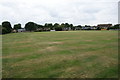
Cricket field at Freeland
This acts as a general recreation ground for the village.
Image: © Bill Boaden
Taken: 31 Jul 2014
0.06 miles
4
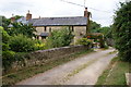
Little Blenheim
A former farm on the edge of Freeland.
Image: © Bill Boaden
Taken: 31 Jul 2014
0.06 miles
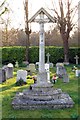
5
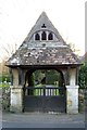
The lych gate to St Mary the Virgin parish church
Image: © Steve Daniels
Taken: 19 Mar 2014
0.07 miles
6
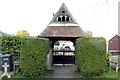
The lych gate to St Mary the Virgin parish church
Image: © Steve Daniels
Taken: 19 Mar 2014
0.07 miles
7
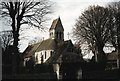
Freeland - St Mary the Virgin
Church of St Mary the Virgin (analogue photography), unaltered Victorian Gothic church of 1870, designed by J. L. Pearson.
Image: © Oxfordian Kissuth
Taken: Unknown
0.08 miles
9
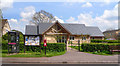
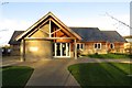
Freeland Village Hall
This was opened in 2011 by David Cameron, who was the Prime Minister when this picture was taken, and also the MP for round here.
Image: © Des Blenkinsopp
Taken: 30 Apr 2014
0.08 miles