IMAGES TAKEN NEAR TO
Witney Road, WITNEY, OX29 7TX
Introduction
This page details the photographs taken nearby to Witney Road, OX29 7TX by members of the Geograph project.
The Geograph project started in 2005 with the aim of publishing, organising and preserving representative images for every square kilometre of Great Britain, Ireland and the Isle of Man.

There are currently over 7.5m images from over14,400 individuals and you can help contribute to the project by visiting https://www.geograph.org.uk
Image Map (Loading...)


Getting Data...Please wait
Leaflet Map data © OpenStreetMap
Images are licensed for reuse under creativecommons.org/licenses/by-sa/2.0
Notes
- Clicking on the map will re-center to the selected point.
- The higher the marker number, the further away the image location is from the centre of the postcode.
Image Listing (34 Images Found)
Images are licensed for reuse under creativecommons.org/licenses/by-sa/2.0
Image
Details
Distance


3

Witney Road - viewed from near Chapel
Image: © Betty Longbottom
Taken: 10 Aug 2013
0.04 miles
4
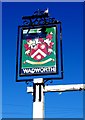
The Strickland Arms (2) - sign, 11 Witney Road, Ducklington
This is or was a Wadworths pub, but it's not clear if they still own it, although their famous 6X beer is normally on sale. Wadworths are a well-known brewery in Devizes, Wiltshire, who acquired a number of public houses in Oxfordshire from another brewery.
The pub gets its name from the Strickland family, who were local landowners living at Cokethorpe Park. The house seems to have become a private school. The pub sign has the family's coat of arms and their French motto "A la volonté de Dieu", translates as "In the Will of God".
Image
Update March 2018:- The pub closed in January 2015.
Image: © P L Chadwick
Taken: 26 May 2012
0.07 miles
5
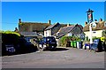
The Strickland Arms (1), 11 Witney Road, Ducklington
One of the village's two public houses. Food is available. The building is Grade II listed. Originally a house dating from the mid to late 17th century, with later alterations, at some date it became a public house. There is a wing dating from about 1850.
Image
Update March 2018:- This pub closed in January 2015.
Image: © P L Chadwick
Taken: 26 May 2012
0.07 miles
6
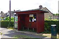
Bus shelter, Witney Road, Ducklington, Oxon
Located near the junction of Witney Road and Curbridge Road. Adjacent to the shelter is a telephone kiosk and a litter bin.
Image: © P L Chadwick
Taken: 25 Aug 2018
0.09 miles
7

Electricity Substation No P4ZZ - Witney Road
Image: © Betty Longbottom
Taken: 10 Aug 2013
0.10 miles
8
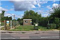
The Moors (Ducklington) Pumping Station, Witney Road, Ducklington, Oxon
The pumping station belongs to Thames Water who supply this area. One of the green cabinets appears to relate to fibre broadband equipment provided by Openreach. The others are probably connected with broadband and/or telephone services.
Image: © P L Chadwick
Taken: 25 Aug 2018
0.10 miles

10
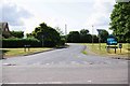
Curbridge Road, Ducklington, Oxon
Curbridge Road is a residential cul-de-sac with several residential roads branching off. It is seen here from its junction with Witney Road.
Image: © P L Chadwick
Taken: 25 Aug 2018
0.10 miles