IMAGES TAKEN NEAR TO
Hardwick, WITNEY, OX29 7QF
Introduction
This page details the photographs taken nearby to OX29 7QF by members of the Geograph project.
The Geograph project started in 2005 with the aim of publishing, organising and preserving representative images for every square kilometre of Great Britain, Ireland and the Isle of Man.

There are currently over 7.5m images from over14,400 individuals and you can help contribute to the project by visiting https://www.geograph.org.uk
Image Map
Images are licensed for reuse under creativecommons.org/licenses/by-sa/2.0
Notes
- Clicking on the map will re-center to the selected point.
- The higher the marker number, the further away the image location is from the centre of the postcode.
Image Listing (5 Images Found)
Images are licensed for reuse under creativecommons.org/licenses/by-sa/2.0
Image
Details
Distance
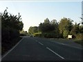
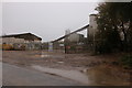
2
The B4449, Hardwick
At the entrance to Richworth Linear Fisheries
Image: © David Howard
Taken: 9 Nov 2019
0.06 miles
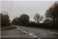
3
Straight stretch of the B4449
Heading towards Stanton Harcourt.
Image: © andrew auger
Taken: 1 Oct 2009
0.11 miles
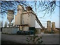
4
Disused quarry on the B4449, Hardwick
There are few quarries left along this road as most have been emptied out and flooded for lakes. This one is currently up for sale.
Image: © David Howard
Taken: 9 Nov 2019
0.20 miles