IMAGES TAKEN NEAR TO
Bampton Road, WITNEY, OX29 7PF
Introduction
This page details the photographs taken nearby to Bampton Road, OX29 7PF by members of the Geograph project.
The Geograph project started in 2005 with the aim of publishing, organising and preserving representative images for every square kilometre of Great Britain, Ireland and the Isle of Man.

There are currently over 7.5m images from over14,400 individuals and you can help contribute to the project by visiting https://www.geograph.org.uk
Image Map
Images are licensed for reuse under creativecommons.org/licenses/by-sa/2.0
Notes
- Clicking on the map will re-center to the selected point.
- The higher the marker number, the further away the image location is from the centre of the postcode.
Image Listing (9 Images Found)
Images are licensed for reuse under creativecommons.org/licenses/by-sa/2.0
Image
Details
Distance
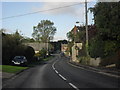
2
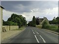
Bend in the A4095
In Curbridge. Well Lane leads off to the left on the bend.
Image: © andrew auger
Taken: 16 Oct 2010
0.07 miles
3
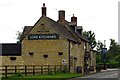
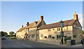
The Lord Kitchener on Bampton Road
The Lord Kitchener is a former Morrells pub.
Image: © Steve Daniels
Taken: 1 Jun 2014
0.12 miles
4
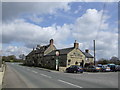
The Lord Kitchener at Curbridge
On the main road at the south end of the village.
Image: © Des Blenkinsopp
Taken: 24 May 2016
0.13 miles
5
Lord Kitchener, Curbridge
Greene King house
Image: © al partington
Taken: 4 Apr 2006
0.19 miles
8
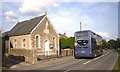
Curbridge Village Hall
In a former chapel. 1902 is the date above the door.
Plus a Stagecoach bus for good measure.
Image: © Des Blenkinsopp
Taken: 21 Jul 2012
0.23 miles