IMAGES TAKEN NEAR TO
Olley Crescent, WITNEY, OX29 7DD
Introduction
This page details the photographs taken nearby to Olley Crescent, OX29 7DD by members of the Geograph project.
The Geograph project started in 2005 with the aim of publishing, organising and preserving representative images for every square kilometre of Great Britain, Ireland and the Isle of Man.

There are currently over 7.5m images from over14,400 individuals and you can help contribute to the project by visiting https://www.geograph.org.uk
Image Map (3 Images)


Getting Data...Please wait
Leaflet Map data © OpenStreetMap
Images are licensed for reuse under creativecommons.org/licenses/by-sa/2.0
Notes
- Clicking on the map will re-center to the selected point.
- The higher the marker number, the further away the image location is from the centre of the postcode.
Image Listing (3 Images Found)
Images are licensed for reuse under creativecommons.org/licenses/by-sa/2.0
Image
Details
Distance
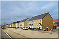
1

Centenary Way and Alice Batt Road
Something of a frontier town feel about this place at the moment, with new stuff going up all the time and residents cars and contractors vehicles in about equal numbers.
Image: © Des Blenkinsopp
Taken: 15 Oct 2020
0.06 miles
2
Alice Batt Road
The finishing touches are still being done as the new residents move in.
Alice Maud Batt was a local woman who was awarded the Albert Medal for bravery in the medical services during the first world war. http://www.vconline.org.uk/alice-m-batt-am/4594741075
Image: © Des Blenkinsopp
Taken: 15 Oct 2020
0.17 miles