IMAGES TAKEN NEAR TO
Malthouse Lane, WITNEY, OX29 7AE
Introduction
This page details the photographs taken nearby to Malthouse Lane, OX29 7AE by members of the Geograph project.
The Geograph project started in 2005 with the aim of publishing, organising and preserving representative images for every square kilometre of Great Britain, Ireland and the Isle of Man.

There are currently over 7.5m images from over14,400 individuals and you can help contribute to the project by visiting https://www.geograph.org.uk
Image Map
Images are licensed for reuse under creativecommons.org/licenses/by-sa/2.0
Notes
- Clicking on the map will re-center to the selected point.
- The higher the marker number, the further away the image location is from the centre of the postcode.
Image Listing (11 Images Found)
Images are licensed for reuse under creativecommons.org/licenses/by-sa/2.0
Image
Details
Distance
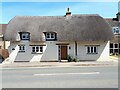
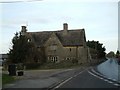
1
The old entrance to Malthouse Farm, Brighthampton
The farm appears to be long gone unless it's hiding behind the new houses.
Image: © David Howard
Taken: 9 Nov 2019
0.02 miles
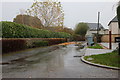
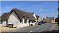
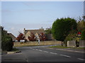
4
Abingdon Road, Brighthampton
There was a large hedge covering the fence in 2011 which has now gone, along with a second tree.
Image: © David Howard
Taken: 9 Nov 2019
0.14 miles
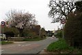
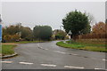
5
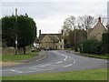
Junction of the B4449 and the A415
In Brighthampton.
Image: © andrew auger
Taken: 17 Oct 2009
0.14 miles
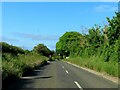
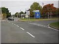
8
A415 in Standlake
Approaching the junction with the B4449 to Bampton.
Image: © andrew auger
Taken: 17 Oct 2009
0.16 miles