IMAGES TAKEN NEAR TO
Lymbrook Close, WITNEY, OX29 6XL
Introduction
This page details the photographs taken nearby to Lymbrook Close, OX29 6XL by members of the Geograph project.
The Geograph project started in 2005 with the aim of publishing, organising and preserving representative images for every square kilometre of Great Britain, Ireland and the Isle of Man.

There are currently over 7.5m images from over14,400 individuals and you can help contribute to the project by visiting https://www.geograph.org.uk
Image Map
Images are licensed for reuse under creativecommons.org/licenses/by-sa/2.0
Notes
- Clicking on the map will re-center to the selected point.
- The higher the marker number, the further away the image location is from the centre of the postcode.
Image Listing (17 Images Found)
Images are licensed for reuse under creativecommons.org/licenses/by-sa/2.0
Image
Details
Distance
5
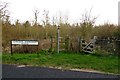
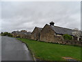
House at South Leigh Station
The house is called South Leigh Station and is on that site. The station was on the Fairford branch line; see Martin Loader's description for its history http://www.martin.loader.btinternet.co.uk/Fairford_Branch.htm, parts of the line opened in 1861. Regular passenger trains ceased in 1962 and freight trains finished in 1970. Martin Loader's site also describes South Leigh station http://www.martin.loader.btinternet.co.uk/South_Leigh.htm .
Image: © David Hawgood
Taken: 17 May 2009
0.12 miles
6
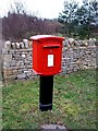
South Leigh Postbox
An unusual shape postbox located in the village of South Leigh.
Image: © Steve Newman
Taken: 10 Jan 2006
0.13 miles
7
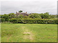
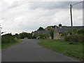
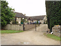
Thatched cottage at South Leigh
View across pasture from the road by the former level crossing.
Image: © David Hawgood
Taken: 17 May 2009
0.14 miles
8
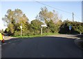
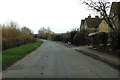
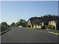
Junction on the edge of South Leigh
The road off to the left goes to the A40 at Barnard Gate, to the right, to Sutton and Stanton Harcourt.
Image: © andrew auger
Taken: 10 Oct 2010
0.15 miles