IMAGES TAKEN NEAR TO
New Yatt Road, WITNEY, OX29 6TS
Introduction
This page details the photographs taken nearby to New Yatt Road, OX29 6TS by members of the Geograph project.
The Geograph project started in 2005 with the aim of publishing, organising and preserving representative images for every square kilometre of Great Britain, Ireland and the Isle of Man.

There are currently over 7.5m images from over14,400 individuals and you can help contribute to the project by visiting https://www.geograph.org.uk
Image Map
Images are licensed for reuse under creativecommons.org/licenses/by-sa/2.0
Notes
- Clicking on the map will re-center to the selected point.
- The higher the marker number, the further away the image location is from the centre of the postcode.
Image Listing (22 Images Found)
Images are licensed for reuse under creativecommons.org/licenses/by-sa/2.0
Image
Details
Distance
2
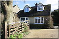
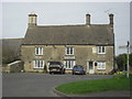
'Providence Cottage', New Yatt Road
Image: © Roger Templeman
Taken: 18 Feb 2016
0.05 miles
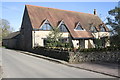
3
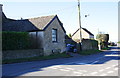
Paddock House outbuilding, New Yatt Road
There is an OS benchmark Image at the base of the outbuilding on the road face of its near angle
Image: © Roger Templeman
Taken: 11 Feb 2016
0.10 miles
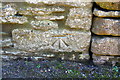
4
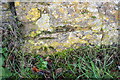
Benchmark on Paddock House outbuilding
Ordnance Survey cut mark benchmark described on the Bench Mark Database at http://www.bench-marks.org.uk/bm73811
Image: © Roger Templeman
Taken: 11 Feb 2016
0.10 miles
5
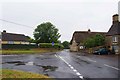
Park Road leading into New Yatt Road, North Leigh, near Witney, Oxon
The road in the foreground, on the right, is Park Road which leads into New Yatt Road in the distance. The road coming in on the left is Common Road.
Image: © P L Chadwick
Taken: 26 Jul 2015
0.13 miles
6
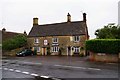
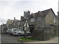
Masons Arms, 5 Park Road, North Leigh, near Witney, Oxon
One of the two surviving public houses in the village. There used to be many more in the past, not all of them open during the same period. The earliest record of this building as a public house dates from 1871, when there were a total of five public houses in the village. Previously it appears to have been a private house. The building is Grade II listed and is mainly early/mid 17th century with a 19th century extension and other later features. The sign above the door with a coat of arms is relatively recent. At first floor level there is also a very faded sign saying real ales. It probably had a brewery name on it too but this cannot easily be deciphered. Today the pub is a free house.
Image: © P L Chadwick
Taken: 26 Jul 2015
0.14 miles
8
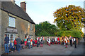
Dancers at The Masons Arms
Folk dancers outside the pub at the end of a sunny day.
Image: © Des Blenkinsopp
Taken: 14 May 2018
0.15 miles
9
'Hereford House', Church Road
There is an OS benchmark Image on the near corner, roadside face, of the house
Image: © Roger Templeman
Taken: 11 Feb 2016
0.16 miles
10
Benchmark on 'Hereford House'
Ordnance Survey cut mark benchmark described on the Bench Mark Database at http://www.bench-marks.org.uk/bm74042
Image: © Roger Templeman
Taken: 11 Feb 2016
0.16 miles