IMAGES TAKEN NEAR TO
OX29 5YX
Introduction
This page details the photographs taken nearby to OX29 5YX by members of the Geograph project.
The Geograph project started in 2005 with the aim of publishing, organising and preserving representative images for every square kilometre of Great Britain, Ireland and the Isle of Man.

There are currently over 7.5m images from over14,400 individuals and you can help contribute to the project by visiting https://www.geograph.org.uk
Image Map
Images are licensed for reuse under creativecommons.org/licenses/by-sa/2.0
Notes
- Clicking on the map will re-center to the selected point.
- The higher the marker number, the further away the image location is from the centre of the postcode.
Image Listing (97 Images Found)
Images are licensed for reuse under creativecommons.org/licenses/by-sa/2.0
Image
Details
Distance
2
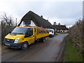
Thatching, Steady's Lane
Three men are in the process of preparing the roof to be re-thatched. The men were beating the old thatch with tools which looked like spades.
Image: © Vieve Forward
Taken: 5 Jan 2016
0.08 miles
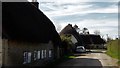
5
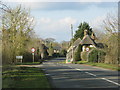
Main Road junction with Steady's Lane
Thatched cottages in this picture are Grade II listed.
Image: © Stuart Logan
Taken: 15 Jul 2012
0.10 miles
6
Upwards of 17 years
Upwards of 17 years. What a nice old phrase. Much more memorable than "over" or "more than".
Image: © Des Blenkinsopp
Taken: 22 Jul 2014
0.10 miles
7
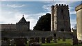
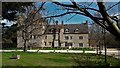
Manor house kitchen and Pope's Tower, Stanton Harcourt
Pope's Tower is named for the poet Alexander Pope, a guest of the Harcourts at the manor. The late mediaeval kitchen on the left with its octagonal roof is a rare survival.
Image: © Chris Brown
Taken: 25 Mar 2017
0.11 miles
8
Air raid shelter, RAF Stanton Harcourt
WW2 air raid shelter on the disused aerodrome that was RAF Stanton Harcourt. This air raid shelter was built opposite the guard house at the main entrance to RAF Stanton Harcourt. http://www.pixture.co.uk/Pages/Stanton%20Harcourt.htm For other photographs of the shelter, see http://www.ukgser.com/forums/showthread.php/151123-RAF-Stanton-Harcourt-another-ruddy-MMC-airfield-write-up and http://www.derelictplaces.co.uk/main/military-sites/2704-raf-stanton-harcourt.html. (Note the mistletoe in the trees in the background).
Image: © Vieve Forward
Taken: 5 Jan 2016
0.11 miles
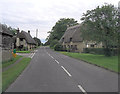
9
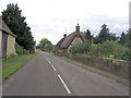
Main Road leaves Stanton Harcourt
The thatched cottages to the right of the picture are Grade II listed.
Image: © Stuart Logan
Taken: 15 Jul 2012
0.11 miles