IMAGES TAKEN NEAR TO
Granary Way, OX29 5BT
Introduction
This page details the photographs taken nearby to Granary Way, OX29 5BT by members of the Geograph project.
The Geograph project started in 2005 with the aim of publishing, organising and preserving representative images for every square kilometre of Great Britain, Ireland and the Isle of Man.

There are currently over 7.5m images from over14,400 individuals and you can help contribute to the project by visiting https://www.geograph.org.uk
Image Map (Loading...)


Getting Data...Please wait
Leaflet Map data © OpenStreetMap
Images are licensed for reuse under creativecommons.org/licenses/by-sa/2.0
Notes
- Clicking on the map will re-center to the selected point.
- The higher the marker number, the further away the image location is from the centre of the postcode.
Image Listing (75 Images Found)
Images are licensed for reuse under creativecommons.org/licenses/by-sa/2.0
Image
Details
Distance
2
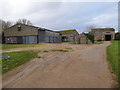
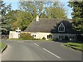
Former WW2 airfield buildings, RAF Stanton Harcourt
Some of these buildings were originally part of RAF Stanton Harcourt, a WW2 airfield. http://www.pixture.co.uk/Pages/Stanton%20Harcourt.htm The building on the right is what remains of the turret trainer and the small building in the centre may have been an office block. For more photographs, see http://www.ukgser.com/forums/showthread.php/151123-RAF-Stanton-Harcourt-another-ruddy-MMC-airfield-write-up and https://sites.google.com/site/derelictionintheshires/military-sites/raf-stanton-harcourt and http://www.derelictplaces.co.uk/main/military-sites/2704-raf-stanton-harcourt.html.
Image: © Vieve Forward
Taken: 5 Jan 2016
0.14 miles
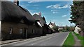
3
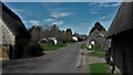
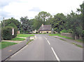
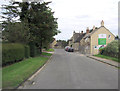
Southern entrance to Stanton Harcourt
An unusual concentration of thatch for this part of Oxfordshire. The road on the right is Steadys Lane.
Image: © Chris Brown
Taken: 25 Mar 2017
0.14 miles
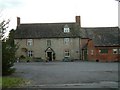
4
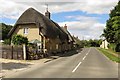
Cottages opposite the Manor, Stanton Harcourt
Image: © Chris Brown
Taken: 25 Mar 2017
0.14 miles
5
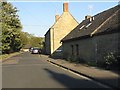
Eastern end of Blackditch, Stanton Harcourt
Image: © Peter Whatley
Taken: 15 Oct 2011
0.15 miles
10
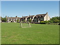
The Green, Stanton Harcourt
The village kindly provided a bench in the shade of a tree where I ate my lunch with this pleasant view. On another bench were two cyclists with a tandem.
Image: © David Hawgood
Taken: 22 May 2007
0.15 miles