IMAGES TAKEN NEAR TO
West End, WITNEY, OX29 5AS
Introduction
This page details the photographs taken nearby to West End, OX29 5AS by members of the Geograph project.
The Geograph project started in 2005 with the aim of publishing, organising and preserving representative images for every square kilometre of Great Britain, Ireland and the Isle of Man.

There are currently over 7.5m images from over14,400 individuals and you can help contribute to the project by visiting https://www.geograph.org.uk
Image Map
Images are licensed for reuse under creativecommons.org/licenses/by-sa/2.0
Notes
- Clicking on the map will re-center to the selected point.
- The higher the marker number, the further away the image location is from the centre of the postcode.
Image Listing (7 Images Found)
Images are licensed for reuse under creativecommons.org/licenses/by-sa/2.0
Image
Details
Distance
1
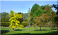
Tree Colours in a Garden
Lovely variated foliage in this very well tended garden.
Image: © Des Blenkinsopp
Taken: 20 Sep 2020
0.07 miles
2
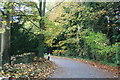
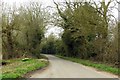
Bend in the road
At West End, between Stanton Harcourt and Bablockhythe.
Image: © andrew auger
Taken: 25 Oct 2009
0.08 miles
7
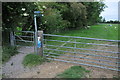
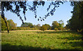
Thames Path at West End
The Thames Path at West End near Stanton Harcourt takes a brief diversion away from the riverbank.
Image: © Philip Halling
Taken: 28 May 2011
0.25 miles