IMAGES TAKEN NEAR TO
Clover Place, WITNEY, OX29 4QL
Introduction
This page details the photographs taken nearby to Clover Place, OX29 4QL by members of the Geograph project.
The Geograph project started in 2005 with the aim of publishing, organising and preserving representative images for every square kilometre of Great Britain, Ireland and the Isle of Man.

There are currently over 7.5m images from over14,400 individuals and you can help contribute to the project by visiting https://www.geograph.org.uk
Image Map
Images are licensed for reuse under creativecommons.org/licenses/by-sa/2.0
Notes
- Clicking on the map will re-center to the selected point.
- The higher the marker number, the further away the image location is from the centre of the postcode.
Image Listing (113 Images Found)
Images are licensed for reuse under creativecommons.org/licenses/by-sa/2.0
Image
Details
Distance


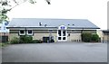
4
Clover Place - viewed from Back Lane
Image: © Betty Longbottom
Taken: 8 Aug 2013
0.05 miles
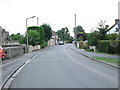
5

Grange Mill, Acre End Street
An old mill with a big yard behind, now residential.
Image: © Des Blenkinsopp
Taken: 9 Jun 2021
0.06 miles

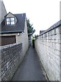
8
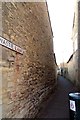
Wastie Lane in Eynsham
Wastie Lane runs between Acre End Street and Clover Place.
Image: © Steve Daniels
Taken: 19 Mar 2014
0.07 miles
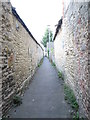
9
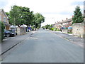
Back Lane - viewed from Clover Place
Image: © Betty Longbottom
Taken: 8 Aug 2013
0.07 miles