IMAGES TAKEN NEAR TO
Hanborough Road, WITNEY, OX29 4LR
Introduction
This page details the photographs taken nearby to Hanborough Road, OX29 4LR by members of the Geograph project.
The Geograph project started in 2005 with the aim of publishing, organising and preserving representative images for every square kilometre of Great Britain, Ireland and the Isle of Man.

There are currently over 7.5m images from over14,400 individuals and you can help contribute to the project by visiting https://www.geograph.org.uk
Image Map
Images are licensed for reuse under creativecommons.org/licenses/by-sa/2.0
Notes
- Clicking on the map will re-center to the selected point.
- The higher the marker number, the further away the image location is from the centre of the postcode.
Image Listing (28 Images Found)
Images are licensed for reuse under creativecommons.org/licenses/by-sa/2.0
Image
Details
Distance
1
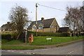
Pillar box at Wytham View / Hanborough Road junction
Image: © Roger Templeman
Taken: 22 Feb 2016
0.04 miles

3

Woodstock Car Sales, opening soon, Eynsham
Image: © David Howard
Taken: 29 Jul 2013
0.12 miles
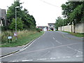
4
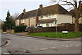
Houses on Spare Acre Lane at Hanborough Road junction
Image: © Roger Templeman
Taken: 22 Feb 2016
0.13 miles
5
Old farm machinery stored in remnants of barn
Image: © Roger Templeman
Taken: 12 Mar 2011
0.17 miles
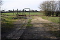
6
Junction of track and footpath
Access to the footpath was originally by a stile which had an Ordnance Survey rivet benchmark on its step
Image: © Roger Templeman
Taken: 22 Feb 2016
0.19 miles
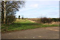
7
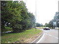
The B4449 exit to Eynsham from the A40 roundabout
Image: © David Howard
Taken: 29 Jul 2013
0.21 miles

10
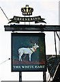
The White Hart (2) - sign, 31 Newland Street, Eynsham
There has been and inn or pub here since at least 1750, and it has operated under its present name since 1835. The white hart was the heraldic symbol of King Richard II, who became king at the age of just nine in 1377. The white hart (which is a male deer or stag) is often portrayed with a golden chain or collar around his neck. This stems from the legend, reported by Aristotle, of Diomedes consecrating a white hart to Diana, the goddess of the hunt, and placing a gold collar around its neck. The sign of the White Hart remains very popular today. The building actually predates King Richard's reign, but was not in use as a pub or inn at that time, as far as is known. It was perhaps connected at some point to a local hunt, but it had other names prior to becoming the White Hart.
The pub has passed through the hands of several breweries over the years, including the defunct Clinch & Co of Witney, Oxon. Today it is a Greene King house. The brewers Greene King are based at Bury St. Edmunds in Suffolk, where they have a brewery. Their pubs division has around 1,600 pubs at present, and has extended well beyond their East Anglian base, particularly as they have taken over many pubs from other now defunct breweries, including this one.
Image
Image: © P L Chadwick
Taken: 19 Nov 2011
0.23 miles