IMAGES TAKEN NEAR TO
Supergas Industrial Estate, Downs Road, WITNEY, OX29 0SZ
Introduction
This page details the photographs taken nearby to Supergas Industrial Estate, Downs Road, OX29 0SZ by members of the Geograph project.
The Geograph project started in 2005 with the aim of publishing, organising and preserving representative images for every square kilometre of Great Britain, Ireland and the Isle of Man.

There are currently over 7.5m images from over14,400 individuals and you can help contribute to the project by visiting https://www.geograph.org.uk
Image Map
Images are licensed for reuse under creativecommons.org/licenses/by-sa/2.0
Notes
- Clicking on the map will re-center to the selected point.
- The higher the marker number, the further away the image location is from the centre of the postcode.
Image Listing (14 Images Found)
Images are licensed for reuse under creativecommons.org/licenses/by-sa/2.0
Image
Details
Distance
1
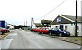
Dallas Keith Ltd, Bromag Industrial Estate, Witney
Dallas Keith (in the building at right of centre with the blue signage) supplies animal feed supplements for ruminants. The company has a manufacturing facility in Stokesley, North Yorkshire.
Image: © Brian Robert Marshall
Taken: 9 Jan 2007
0.05 miles
2
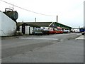
Bromag Industrial Estate, Witney
Another view of this part of the Bromag Industrial Estate. The estate started life as a WWI RAF station and also saw service during WWII.
Image: © Brian Robert Marshall
Taken: 9 Jan 2007
0.05 miles
3
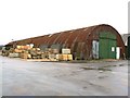
WWII Nissen hut, Bromag Industrial Estate, Witney
This building was occupied by a joinery company but is now apparently vacant. Despite its utilitarian appearance, some might think the building has a certain scruffy charm.
Image: © Brian Robert Marshall
Taken: 9 Jan 2007
0.05 miles
4
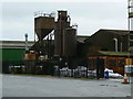
Sandawana Castings, Bromag, Witney
This view shows the ancillary equipment associated with a typical iron foundry including dust extraction plant and sand storage silos. The name 'Sandawana' is a reference to the mining area of Zimbabwe.
Image: © Brian Robert Marshall
Taken: 9 Jan 2007
0.06 miles
5
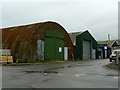
Nissen huts, Bromag Industrial Estate, Witney
Taken on a rather gloomy January day. The further of the two Nissen huts has been fitted with a slightly more imposing façade than its neighbour. The estate was once a military airfield.
Image: © Brian Robert Marshall
Taken: 9 Jan 2007
0.08 miles
6
Sandawana Foundry uses its own products
The foundry shows off its own cast iron railings, gates, gatepost decorative birds, and light fitting. Sandawana means Little Gem in an african language - the founder (perfect word in this application) had spent some time in Rhodesia. The Bromag Industrial Estate is officially at Witney even though Geograph identifies the location as Minster Lovell.
Image: © John Goldsmith
Taken: 1 Oct 2008
0.11 miles
7
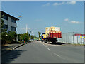
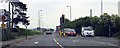
Curbridge Park Road, Witney
An industrial area.
Image: © Robin Webster
Taken: 18 May 2014
0.18 miles
8
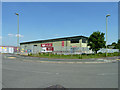
SIG Insulation
A branch on the Curbridge Business Park, Witney.
Image: © Robin Webster
Taken: 18 May 2014
0.18 miles
9
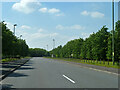
Curbridge Park Road, Witney
An industrial estate road, although it does not look like it.
Image: © Robin Webster
Taken: 18 May 2014
0.18 miles