IMAGES TAKEN NEAR TO
Granary Close, WITNEY, OX29 0AS
Introduction
This page details the photographs taken nearby to Granary Close, OX29 0AS by members of the Geograph project.
The Geograph project started in 2005 with the aim of publishing, organising and preserving representative images for every square kilometre of Great Britain, Ireland and the Isle of Man.

There are currently over 7.5m images from over14,400 individuals and you can help contribute to the project by visiting https://www.geograph.org.uk
Image Map (Loading...)


Getting Data...Please wait
Leaflet Map data © OpenStreetMap
Images are licensed for reuse under creativecommons.org/licenses/by-sa/2.0
Notes
- Clicking on the map will re-center to the selected point.
- The higher the marker number, the further away the image location is from the centre of the postcode.
Image Listing (8 Images Found)
Images are licensed for reuse under creativecommons.org/licenses/by-sa/2.0
Image
Details
Distance
1
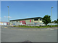
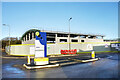
SIG Insulation
A branch on the Curbridge Business Park, Witney.
Image: © Robin Webster
Taken: 18 May 2014
0.13 miles
2
Curbridge Park Road, Witney
An industrial area.
Image: © Robin Webster
Taken: 18 May 2014
0.15 miles
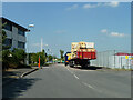
3
Curbridge Park Road, Witney
An industrial estate road, although it does not look like it.
Image: © Robin Webster
Taken: 18 May 2014
0.16 miles
4

Coaches at former Witney Town F.C. ground, 2014
The club folded in 2013. The site is now redeveloped as a housing estate.
Image: © Robin Webster
Taken: 18 May 2014
0.16 miles
5

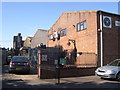
The main stand at Marriott's Stadium, Witney
Image: © Steve Daniels
Taken: 26 Feb 2008
0.17 miles
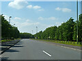
6
Downs Road, Witney
Out in the country until recently, Downs Road is rapidly becoming part of urban Witney as building sites spread over the fields.
Image: © Des Blenkinsopp
Taken: 15 Dec 2020
0.21 miles
7
Sandawana Foundry uses its own products
The foundry shows off its own cast iron railings, gates, gatepost decorative birds, and light fitting. Sandawana means Little Gem in an african language - the founder (perfect word in this application) had spent some time in Rhodesia. The Bromag Industrial Estate is officially at Witney even though Geograph identifies the location as Minster Lovell.
Image: © John Goldsmith
Taken: 1 Oct 2008
0.23 miles
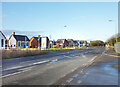
8
Site Entrance, Downs Road
The road into yet another building site on the west side of Witney.
Image: © Des Blenkinsopp
Taken: 15 Dec 2020
0.24 miles