IMAGES TAKEN NEAR TO
Wytham, OXFORD, OX2 8QH
Introduction
This page details the photographs taken nearby to OX2 8QH by members of the Geograph project.
The Geograph project started in 2005 with the aim of publishing, organising and preserving representative images for every square kilometre of Great Britain, Ireland and the Isle of Man.

There are currently over 7.5m images from over14,400 individuals and you can help contribute to the project by visiting https://www.geograph.org.uk
Image Map
Images are licensed for reuse under creativecommons.org/licenses/by-sa/2.0
Notes
- Clicking on the map will re-center to the selected point.
- The higher the marker number, the further away the image location is from the centre of the postcode.
Image Listing (36 Images Found)
Images are licensed for reuse under creativecommons.org/licenses/by-sa/2.0
Image
Details
Distance
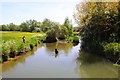
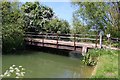
1

Bridge over the millstream at Wytham Mill
Image: © Steve Daniels
Taken: 22 May 2010
0.01 miles
2
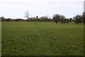
Footpath heading towards Wytham Mill
Footpath heading across the fields towards Wytham Mill
Image: © Shaun Ferguson
Taken: 1 Mar 2008
0.01 miles
3
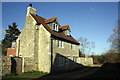
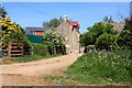
Wytham Mill
There is an OS benchmark Image on the near corner of the house
Image: © Roger Templeman
Taken: 10 Dec 2012
0.01 miles
4
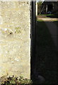
Benchmark on Wytham Mill
Ordnance Survey cut mark described on the Bench Mark Database at http://www.bench-marks.org.uk/bm46499
Image: © Roger Templeman
Taken: 10 Dec 2012
0.01 miles

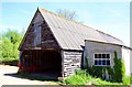
6
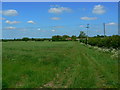
Wytham Mill, Wytham, Oxon
The mill is adjacent to a tributary of the Thames called Seacourt Stream.
Image: © Brian Robert Marshall
Taken: 23 May 2007
0.02 miles