IMAGES TAKEN NEAR TO
Wytham, OXFORD, OX2 8QA
Introduction
This page details the photographs taken nearby to OX2 8QA by members of the Geograph project.
The Geograph project started in 2005 with the aim of publishing, organising and preserving representative images for every square kilometre of Great Britain, Ireland and the Isle of Man.

There are currently over 7.5m images from over14,400 individuals and you can help contribute to the project by visiting https://www.geograph.org.uk
Image Map
Images are licensed for reuse under creativecommons.org/licenses/by-sa/2.0
Notes
- Clicking on the map will re-center to the selected point.
- The higher the marker number, the further away the image location is from the centre of the postcode.
Image Listing (42 Images Found)
Images are licensed for reuse under creativecommons.org/licenses/by-sa/2.0
Image
Details
Distance
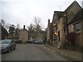
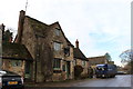
2
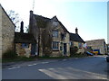
Wytham Village
Wytham by the White Hart
Image: © Shaun Ferguson
Taken: 7 Sep 2012
0.01 miles
3
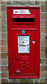
Elizabeth II postbox, Wytham
Postbox No. OX2 198.
Image: © JThomas
Taken: 15 Apr 2023
0.02 miles
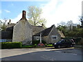
5
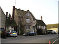
The White Hart Pub, Wytham
Wytham, Oxford, OX2 8QA near to The River Thames
Image: © canalandriversidepubs co uk
Taken: 5 Feb 2010
0.02 miles
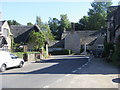
7
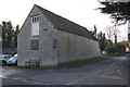
Building at road junction by the White Hart
There is an OS benchmark Image on the corner of the building to the right of the seat
Image: © Roger Templeman
Taken: 10 Dec 2012
0.03 miles
8
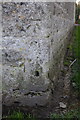
Benchmark on building at junction near the White Hart
Ordnance Survey cut mark benchmark described on the Bench Mark Database at http://www.bench-marks.org.uk/bm46477
Image: © Roger Templeman
Taken: 10 Dec 2012
0.04 miles
9
The White Hart in Wytham in December 2016
Image: © Roger Davies
Taken: 7 Dec 2016
0.04 miles