IMAGES TAKEN NEAR TO
Rosamund Road, OXFORD, OX2 8NU
Introduction
This page details the photographs taken nearby to Rosamund Road, OX2 8NU by members of the Geograph project.
The Geograph project started in 2005 with the aim of publishing, organising and preserving representative images for every square kilometre of Great Britain, Ireland and the Isle of Man.

There are currently over 7.5m images from over14,400 individuals and you can help contribute to the project by visiting https://www.geograph.org.uk
Image Map
Images are licensed for reuse under creativecommons.org/licenses/by-sa/2.0
Notes
- Clicking on the map will re-center to the selected point.
- The higher the marker number, the further away the image location is from the centre of the postcode.
Image Listing (153 Images Found)
Images are licensed for reuse under creativecommons.org/licenses/by-sa/2.0
Image
Details
Distance
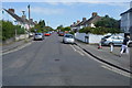
2
Elmthorpe Road
This was the first stage of suburbanisation of Wolvercote, dating from around 1900.
Image: © Alan Murray-Rust
Taken: 20 Oct 2015
0.06 miles
5
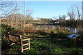
Seat by the lake
Part of Wolvercote Lakes Nature Reserve.
Image: © Des Blenkinsopp
Taken: 7 Dec 2014
0.07 miles
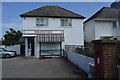
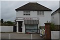
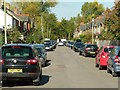
9
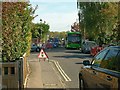
Home Close, Wolvercote
The terminus for Oxford City Buses' route 6 between Wolvercote and the city centre.
Image: © Des Blenkinsopp
Taken: 8 Dec 2014
0.08 miles
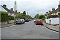
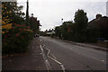
10
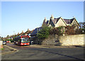
Tight squeeze
The narrow roads in Wolvercote are not ideal for the operation of a bus service, but the road works were making life more than usually difficult.
Image: © Alan Murray-Rust
Taken: 20 Oct 2015
0.08 miles