IMAGES TAKEN NEAR TO
Lovelace Road, OXFORD, OX2 8LP
Introduction
This page details the photographs taken nearby to Lovelace Road, OX2 8LP by members of the Geograph project.
The Geograph project started in 2005 with the aim of publishing, organising and preserving representative images for every square kilometre of Great Britain, Ireland and the Isle of Man.

There are currently over 7.5m images from over14,400 individuals and you can help contribute to the project by visiting https://www.geograph.org.uk
Image Map
Images are licensed for reuse under creativecommons.org/licenses/by-sa/2.0
Notes
- Clicking on the map will re-center to the selected point.
- The higher the marker number, the further away the image location is from the centre of the postcode.
Image Listing (90 Images Found)
Images are licensed for reuse under creativecommons.org/licenses/by-sa/2.0
Image
Details
Distance
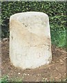
1
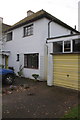
#19 Lovelace Road
There is an OS benchmark Image on the side of the front corner of the house, between the trellis and the yellow gate.
Image: © Roger Templeman
Taken: 13 Nov 2012
0.04 miles
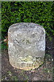
2
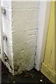
Benchmark on #19 Lovelace Road
Ordnance Survey cut mark benchmark described on the Bench Mark Database at http://www.bench-marks.org.uk/bm46195
Image: © Roger Templeman
Taken: 13 Nov 2012
0.04 miles
3
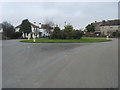
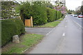
Harbord Road
Roundabout Harbord Road
Image: © Shaun Ferguson
Taken: 23 Jan 2010
0.04 miles
4
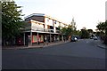
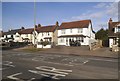
Kendal Crescent Shops
Parade of shops in Kendal Crescent, Cutteslowe, Oxford
Image: © Tony Culshaw
Taken: 17 Jul 2005
0.05 miles
5
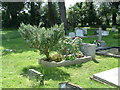
Grave of JRR Tolkien
The grave of JRR Tolkien and his wife in Wolvercote Cemetery
Image: © Michael Parry
Taken: 26 May 2006
0.05 miles
6
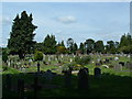
Wolvercote Cemetery
A number of monuments are supported or have been laid flat for Health & Safety reasons.
Image: © Michael Parry
Taken: 26 May 2006
0.05 miles
7
Banbury Road in Cutteslowe
There is a milestone Image in the verge at the left hand side of the image
Image: © Roger Templeman
Taken: 27 Apr 2016
0.07 miles
9
Milestone (Oxford 2 Banbury 20) beside Banbury Road
There appears to the remains of an Ordnance Survey rivet benchmark on top of the stone: the mark is described on the Bench Mark Database at http://www.bench-marks.org.uk/bm75135
Image: © Roger Templeman
Taken: 27 Apr 2016
0.09 miles
10
Old Milestone by the A4260, Banbury Road, Cuttesloe
Oxford tombstone by the A4260, in parish of Oxford (Oxford District), Banbury Road; by No.241/243 was St Frideswide Farm, North of by-pass roundabout, on neat grass verge between hedge and footpath, West side of road. Broken and patched back together.
Inscription reads:-
OXFORD
(2)
BANBURY
20
Grade II listed.
List Entry Number: 1369696 https://historicengland.org.uk/listing/the-list/list-entry/1369696
Surveyed
Milestone Society National ID: OX_oxba02
Image: © Milestone Society
Taken: Unknown
0.09 miles