IMAGES TAKEN NEAR TO
Foxton Close, OXFORD, OX2 8LB
Introduction
This page details the photographs taken nearby to Foxton Close, OX2 8LB by members of the Geograph project.
The Geograph project started in 2005 with the aim of publishing, organising and preserving representative images for every square kilometre of Great Britain, Ireland and the Isle of Man.

There are currently over 7.5m images from over14,400 individuals and you can help contribute to the project by visiting https://www.geograph.org.uk
Image Map
Images are licensed for reuse under creativecommons.org/licenses/by-sa/2.0
Notes
- Clicking on the map will re-center to the selected point.
- The higher the marker number, the further away the image location is from the centre of the postcode.
Image Listing (89 Images Found)
Images are licensed for reuse under creativecommons.org/licenses/by-sa/2.0
Image
Details
Distance
1
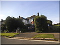
Houses on Five Mile Drive, Cutteslowe
It's actually about half a mile long
Image: © David Howard
Taken: 17 Sep 2017
0.06 miles
2
Five Mile Drive
Looking at the pictures for this square you can see how given over to transport it is. Roads, railway and canal all feature heavily in the collection.
But there are some people living here as well.
Image: © Des Blenkinsopp
Taken: 8 Dec 2014
0.07 miles
3
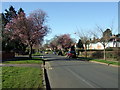
Five Mile Drive, looking west
Broad residential avenue running between the upper ends of Banbury and Woodstock Roads and lined with well-appointed houses standing in generous gardens. In earlier times it was known as Long Hedge and then Horsemonger Lane. Its present name derives from the fact that the circular route from the centre of Oxford, up one and down the other main northern thoroughfares, became known as 'The Five Mile' by walkers and riders who wanted to take the air without passing beyond the tollgates. The area was developed as a suburb in the 1930s when the name was officially given.
Image: © Natasha Ceridwen de Chroustchoff
Taken: 4 Mar 2008
0.07 miles
4

Benchmark on #50 Five Mile Drive
Ordnance Survey cut mark benchmark described on the Bench Mark Database at http://www.bench-marks.org.uk/bm46197
Image: © Roger Templeman
Taken: 13 Nov 2012
0.07 miles
5
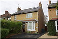
#50 Five Mile Drive
There is an OS benchmark Image on the side of the house at the front corner
Image: © Roger Templeman
Taken: 13 Nov 2012
0.07 miles
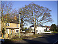
6
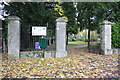
Entrance to Wolvercote Cemetery from Five Mile Drive
There is an OS benchmark Image on the middle gatepost
Image: © Roger Templeman
Taken: 13 Nov 2012
0.09 miles
7
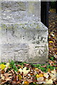
Benchmark on gatepost at entrance to Wolvercote Cemetery
This is the entrance from Five Mile Drive. The Ordnance Survey cut mark benchmark is described on the Bench Mark Database at http://www.bench-marks.org.uk/bm46253
Image: © Roger Templeman
Taken: 13 Nov 2012
0.09 miles
8
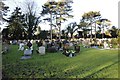
Wolvercote Cemetery over JRR Tolkien's grave
Image: © Sarah Charlesworth
Taken: 8 Oct 2010
0.09 miles
9
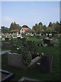
Wolvercote Cemetery
One of the burial areas in Wolvercote cemetery.
Image: © Bill Nicholls
Taken: 9 Jan 2014
0.10 miles
10
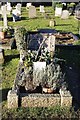
J.R.R. Tolkien
Can't say I was not disappointed to see his grave, I felt it was not that well looked after for such a famous author.
Image: © Bill Nicholls
Taken: 9 Jan 2014
0.10 miles