IMAGES TAKEN NEAR TO
Carey Close, OXFORD, OX2 8HX
Introduction
This page details the photographs taken nearby to Carey Close, OX2 8HX by members of the Geograph project.
The Geograph project started in 2005 with the aim of publishing, organising and preserving representative images for every square kilometre of Great Britain, Ireland and the Isle of Man.

There are currently over 7.5m images from over14,400 individuals and you can help contribute to the project by visiting https://www.geograph.org.uk
Image Map
Images are licensed for reuse under creativecommons.org/licenses/by-sa/2.0
Notes
- Clicking on the map will re-center to the selected point.
- The higher the marker number, the further away the image location is from the centre of the postcode.
Image Listing (95 Images Found)
Images are licensed for reuse under creativecommons.org/licenses/by-sa/2.0
Image
Details
Distance
2
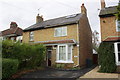
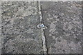
#50 Five Mile Drive
There is an OS benchmark Image on the side of the house at the front corner
Image: © Roger Templeman
Taken: 13 Nov 2012
0.07 miles
3
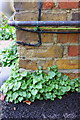
Benchmark on #50 Five Mile Drive
Ordnance Survey cut mark benchmark described on the Bench Mark Database at http://www.bench-marks.org.uk/bm46197
Image: © Roger Templeman
Taken: 13 Nov 2012
0.07 miles
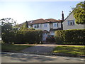
5
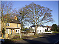
Carey Close
Five Mile Drive passing Carey Close
Image: © Shaun Ferguson
Taken: 23 Jan 2010
0.08 miles
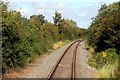
6
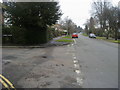
Five Mile Drive
Looking at the pictures for this square you can see how given over to transport it is. Roads, railway and canal all feature heavily in the collection.
But there are some people living here as well.
Image: © Des Blenkinsopp
Taken: 8 Dec 2014
0.08 miles

8

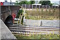
Railway bridge on Five Mile Drive
On the left of the image the Woodstock Road roundabout. There is an OS benchmark Image on top of the parapet near the junction of the parapet with the ivy-clad wooden fence
Image: © Roger Templeman
Taken: 13 Nov 2012
0.10 miles
9
Benchmark on railway bridge parapet, Five Mile Drive
Ordnance Survey rivet benchmark described on the Bench Mark Database at http://www.bench-marks.org.uk/bm46119
Image: © Roger Templeman
Taken: 13 Nov 2012
0.10 miles
10
Wolvercote Tunnel north entrance
Wolvercote Tunnel passes under Wolvercote Roundabout in the north of Oxford. The ex LNWR Bletchley to Oxford railway passes through the tunnel. When the line became less used, it made a perfect roosting place for bats. On reconstruction of the line for the Chiltern Railways new services to Oxford, the tunnel was refurbished and equipped with 'Bat Lights' which are triggered by the passing of trains. This is to persuade the nocturnal animals to remain at roost when a train passes and not fly off and possibly get injured in the process. The 'Bat lights' are fitted along the tunnel walls and on posts at the entrances to the tunnel, as seen here.
Image: © Bob Walters
Taken: 1 Aug 2019
0.10 miles