IMAGES TAKEN NEAR TO
Collett Drive, OXFORD, OX2 8FU
Introduction
This page details the photographs taken nearby to Collett Drive, OX2 8FU by members of the Geograph project.
The Geograph project started in 2005 with the aim of publishing, organising and preserving representative images for every square kilometre of Great Britain, Ireland and the Isle of Man.

There are currently over 7.5m images from over14,400 individuals and you can help contribute to the project by visiting https://www.geograph.org.uk
Image Map
Images are licensed for reuse under creativecommons.org/licenses/by-sa/2.0
Notes
- Clicking on the map will re-center to the selected point.
- The higher the marker number, the further away the image location is from the centre of the postcode.
Image Listing (102 Images Found)
Images are licensed for reuse under creativecommons.org/licenses/by-sa/2.0
Image
Details
Distance
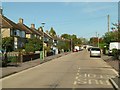
2
Home Close, Lower Wolvercote
Complete with horrible concrete road surface.
Image: © Richard Vince
Taken: 8 Nov 2016
0.11 miles
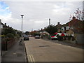
3
Home Close, Wolvercote
Part of the inter-war development of Wolvercote as a suburb of Oxford.
Image: © Alan Murray-Rust
Taken: 20 Oct 2015
0.12 miles
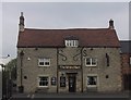
5
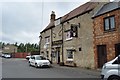
The White Hart
Grade II listed. https://britishlistedbuildings.co.uk/101116394-the-white-hart-public-house-oxford
Image: © N Chadwick
Taken: 16 Jun 2018
0.12 miles
7
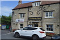
The White Hart Pub, Wolvercote
Godstow Road, Wolvercote, Oxford, OX2 8PG close to the Oxford Canal
Image: © canalandriversidepubs co uk
Taken: 5 Feb 2010
0.12 miles
8
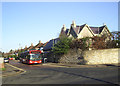
Home Close, Wolvercote
The terminus for Oxford City Buses' route 6 between Wolvercote and the city centre.
Image: © Des Blenkinsopp
Taken: 8 Dec 2014
0.12 miles
9
The former paper mill in Mill Road
Wolvercote Paper Mill is awaiting redevelopment.
Image: © Steve Daniels
Taken: 7 Mar 2017
0.12 miles
10
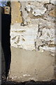
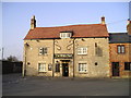
Benchmark on The White Hart public house
Ordnance Survey cut mark benchmark described on the Bench Mark Database at http://www.bench-marks.org.uk/bm46252
Image: © Roger Templeman
Taken: 1 Dec 2012
0.12 miles