IMAGES TAKEN NEAR TO
Ulfgar Road, OXFORD, OX2 8FH
Introduction
This page details the photographs taken nearby to Ulfgar Road, OX2 8FH by members of the Geograph project.
The Geograph project started in 2005 with the aim of publishing, organising and preserving representative images for every square kilometre of Great Britain, Ireland and the Isle of Man.

There are currently over 7.5m images from over14,400 individuals and you can help contribute to the project by visiting https://www.geograph.org.uk
Image Map
Images are licensed for reuse under creativecommons.org/licenses/by-sa/2.0
Notes
- Clicking on the map will re-center to the selected point.
- The higher the marker number, the further away the image location is from the centre of the postcode.
Image Listing (130 Images Found)
Images are licensed for reuse under creativecommons.org/licenses/by-sa/2.0
Image
Details
Distance
1
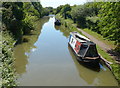
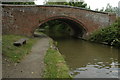
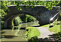
The Oxford Canal near Upper Wolvercote
Looking south from bridge 236: Wolvercote Green Field Bridge.
Image: © Mat Fascione
Taken: 15 Jun 2015
0.04 miles
4
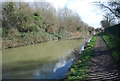
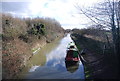
Bridge 236, Oxford Canal
Bridge 236 at Wolvercote on the Oxford Canal.
Image: © Philip Halling
Taken: 4 Jul 2009
0.05 miles
6
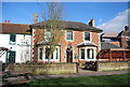
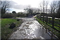
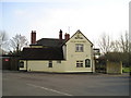
The Plough, Wolvercote
The Plough overlooks Wolvercote Green.
Image: © Philip Halling
Taken: 4 Jul 2009
0.06 miles
8
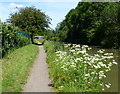
Bridge 236: Wolvercote Green Field Bridge
Crossing the Oxford Canal near Upper Wolvercote.
Image: © Mat Fascione
Taken: 15 Jun 2015
0.06 miles
9
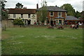
The Plough Pub, Wolvercote Green
Wolvercote Green, Oxford, OX2 8BD on the Oxford Canal
Image: © canalandriversidepubs co uk
Taken: 5 Feb 2010
0.06 miles