IMAGES TAKEN NEAR TO
Woodstock Road, OXFORD, OX2 8BZ
Introduction
This page details the photographs taken nearby to Woodstock Road, OX2 8BZ by members of the Geograph project.
The Geograph project started in 2005 with the aim of publishing, organising and preserving representative images for every square kilometre of Great Britain, Ireland and the Isle of Man.

There are currently over 7.5m images from over14,400 individuals and you can help contribute to the project by visiting https://www.geograph.org.uk
Image Map
Images are licensed for reuse under creativecommons.org/licenses/by-sa/2.0
Notes
- Clicking on the map will re-center to the selected point.
- The higher the marker number, the further away the image location is from the centre of the postcode.
Image Listing (78 Images Found)
Images are licensed for reuse under creativecommons.org/licenses/by-sa/2.0
Image
Details
Distance
1
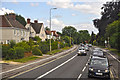
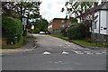
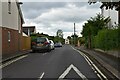
Oxford : Woodstock Road A4144
Looking along Woodstock Road as it heads into Oxford.
Image: © Lewis Clarke
Taken: 29 Jun 2014
0.03 miles
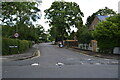
3
Chestnuts at night
Woodstock Road / Davenant Road
Image: © Anthony O'Neil
Taken: Unknown
0.05 miles
4
Woodstock Close, Oxford
Woodstock Close is a residential cul-de-sac in the outer suburbs of Oxford.
Image: © Malc McDonald
Taken: 26 Oct 2024
0.06 miles
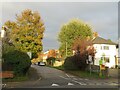
7
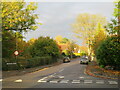
Davenant Road, Oxford
Davenant Road is a residential road in the outer suburbs of Oxford. This image was taken in late October. Late afternoon sunshine highlights the autumn colours on the trees.
Image: © Malc McDonald
Taken: 26 Oct 2024
0.06 miles
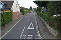
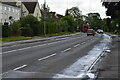
10
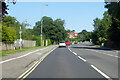
A4144 Woodstock Road, Oxford
Heading north out of town.
Image: © Robin Webster
Taken: 18 Jul 2021
0.08 miles