IMAGES TAKEN NEAR TO
Fairlawn End, OXFORD, OX2 8AR
Introduction
This page details the photographs taken nearby to Fairlawn End, OX2 8AR by members of the Geograph project.
The Geograph project started in 2005 with the aim of publishing, organising and preserving representative images for every square kilometre of Great Britain, Ireland and the Isle of Man.

There are currently over 7.5m images from over14,400 individuals and you can help contribute to the project by visiting https://www.geograph.org.uk
Image Map
Images are licensed for reuse under creativecommons.org/licenses/by-sa/2.0
Notes
- Clicking on the map will re-center to the selected point.
- The higher the marker number, the further away the image location is from the centre of the postcode.
Image Listing (163 Images Found)
Images are licensed for reuse under creativecommons.org/licenses/by-sa/2.0
Image
Details
Distance
5
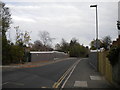
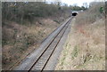
Bridge carrying First Turn, Wolvercote
This narrow bridge carries the eccentrically named First Turn across the Oxford to Bicester railway line, this section of which (between Oxford and the new Oxford Parkway station) was closed when this photograph was taken. The bridge parapets appear to have been rebuilt very recently, with a view to the potential electrification of the railway as part of the East West Rail scheme (which, given the serious delays and cost overruns incurred by current railway electrification projects, appears some way off).
Image: © Richard Vince
Taken: 8 Nov 2016
0.06 miles
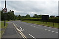
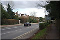
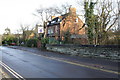
7
First Turn, Wolvercote
First Turn is a minor road in the village of Wolvercote, on the outskirts of Oxford.
Image: © Malc McDonald
Taken: 26 Oct 2024
0.07 miles
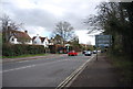
8
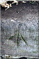
Benchmark on First Turn railway bridge
Ordnance Survey rivet benchmark described on the Benchmark Database at http://www.bench-marks.org.uk/bm23163
Image: © Roger Templeman
Taken: 1 Dec 2012
0.07 miles
9
First Turn railway bridge and houses
There is an OS benchmark Image on top of the far end of the bridge parapet
Image: © Roger Templeman
Taken: 1 Dec 2012
0.07 miles
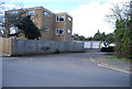
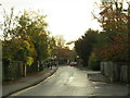
10
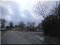
Road works on First Turn, Wolvercote
By the position it appears to be on the railway bridge. Until the 90s it was a goods line mainly taking gravel from the Amey Roadstone quarry and was then upgraded to passenger use.
Image: © David Howard
Taken: 21 Feb 2016
0.07 miles