IMAGES TAKEN NEAR TO
Moorland Road, WITNEY, OX28 6LT
Introduction
This page details the photographs taken nearby to Moorland Road, OX28 6LT by members of the Geograph project.
The Geograph project started in 2005 with the aim of publishing, organising and preserving representative images for every square kilometre of Great Britain, Ireland and the Isle of Man.

There are currently over 7.5m images from over14,400 individuals and you can help contribute to the project by visiting https://www.geograph.org.uk
Image Map
Images are licensed for reuse under creativecommons.org/licenses/by-sa/2.0
Notes
- Clicking on the map will re-center to the selected point.
- The higher the marker number, the further away the image location is from the centre of the postcode.
Image Listing (43 Images Found)
Images are licensed for reuse under creativecommons.org/licenses/by-sa/2.0
Image
Details
Distance
3

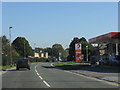
Welch Way
Welch Way and Witney Community Hospital in the background.
Image: © Miranda Hodgson
Taken: 6 Jan 2010
0.08 miles
4
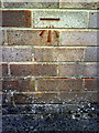
Benchmark on the side of #193 Moorland Road
Ordnance Survey cut mark benchmark described on the Bench Mark Database at http://www.bench-marks.org.uk/bm37251
Image: © Roger Templeman
Taken: 5 Mar 2011
0.08 miles
5

Apartments in Corn Bar, Witney, Oxon
Corn Bar is a small modern residential development, off Corn Street. It includes these two apartment blocks. This view is in the direction of Corn Street.
Image: © P L Chadwick
Taken: 4 Jun 2020
0.11 miles
7

Benchmark on the Thames Water Pumping Station, Dark Lane
Ordnance Survey cut mark benchmark described on the Bench Mark Database at http://www.bench-marks.org.uk/bm37212
Image: © Roger Templeman
Taken: 5 Mar 2011
0.13 miles
8
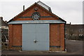
Thames Water Witney Pumping Station, Dark Lane
Photo taken from Moor Avenue. The Ordnance Survey benchmark on the corner to the left of the doors is shown at Image
Image: © Roger Templeman
Taken: 5 Mar 2011
0.13 miles
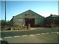
9
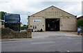
Stagecoach Bus Garage, Corn Street, Witney, Oxon
Stagecoach use this garage for their locally based buses. The building was originally built for Oxford Motor Services, probably in the early 1920's. It seems it was definitely there by 1929. At that time the garage was on the edge of the town. With expansion over the years, the garage is now in a residential area. Some local residents have for several years been advocating that the garage should be relocated elsewhere. So far this hasn't happened.
Image: © P L Chadwick
Taken: 4 Jun 2020
0.13 miles
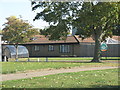
10
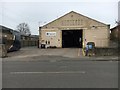
Bus Garage
Witney bus garage on Corn Street
Image: © Shaun Ferguson
Taken: 9 Mar 2019
0.13 miles